Kiruhura geodata
Kiruhura (Western Region) is a seat of a second-order administrative division; located in Uganda in Africa/Kampala (GMT+3) time zone. With population of 14,000 people, there are 50 cities with bigger population in this country. Compared to other cities in Uganda, 82.2% of cities are located further ↑North; 79.5% of cities are located further →East and 77.4% of cities have lower elevation than Kiruhura. Note1
Administrative division(s):
- Level 1: Western Region
- Level 2: Kiruhura District
- Level 3: Nyabushozi
- Level 4: Kiruhura Town Council


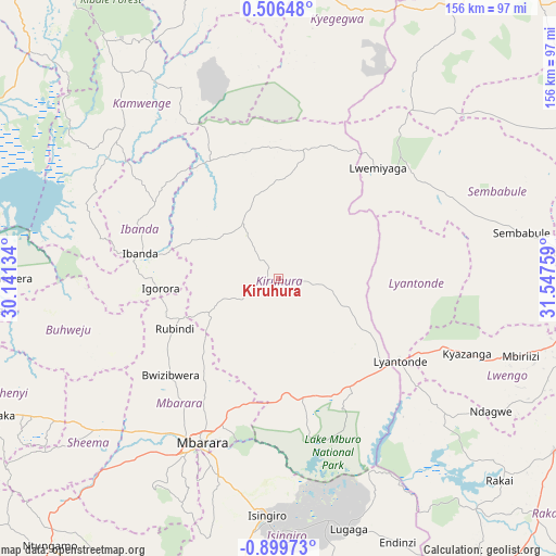
Kiruhura GPS coordinates[2]
0° 11' 47.904" South, 30° 50' 40.056" East
| Map corner | latitude | longitude |
|---|---|---|
| Upper-left | 0.50648°, | 30.14134° |
| Center: | -0.19664°, | 30.84446° |
| Lower-right: | -0.89973°, | 31.54759° |
| Map W x H: | 156.4×156.4 km | = 97.2×97.2mi |
| max Lat: | 3.66088° ⇑82.2% North |
| Kiruhura: | -0.19664° |
| min Lat: | ⇓17.8% South -1.28538° |
| min Long | Kiruhura | max Long |
| 29.65° | 30.84446° | 34.95° |
| W 20.5%⇐ | ⇒79.5% E |
Elevation
Elevation of Kiruhura is 1344 m = 4409 ft, and this is 85 m = 279 ft above average elevation for this country.
| Max E: |
4129 m = 13547 ft | 22.6% |
| Kiruhura | 1344 m 4409 ft | |
| Avg. | 1259 m = 4131 ft | |
Min E: |
622 m = 2041 ft | 77.4% |
See also: Uganda elevation on elevation.city.
Geographical zone
Kiruhura is located in South Torrid zone (between Equator and Tropic of Capricorn). Distance of Equator is 21.9 km =13.6 mi to North.| Distance of | km | miles | from Kiruhura |
|---|---|---|---|
| Equator | 21.9 | 13.6 | to North |
| Tropic Capricorn | 2584.1 | 1605.7 | to South |
| Antarctic Circle | 7379.3 | 4585.3 | to South |
| South Pole | 9985.2 | 6204.5 | to South |


Nearby cities:
15 places around Kiruhura: (largest is in red/bold)
• Buhweju
62.9 km =39.1 mi,  254°
254°
• Bukomansimbi
84.6 km =52.6 mi,  87°
87°
• Bushenyi
82.4 km =51.2 mi,  242°
242°
• Bwizibwera
50.1 km =31.1 mi,  208°
208°
• Ibanda
39.3 km =24.4 mi,  280°
280°
• Isingiro
74.7 km =46.4 mi,  181°
181°
• Kamwenge
60.8 km =37.8 mi,  314°
314°
• Kibingo
65.9 km =40.9 mi,  223°
223°
• Kyegegwa
80.7 km =50.1 mi,  15°
15°
• Lwengo
67.2 km =41.8 mi,  111°
111°
• Lyantonde
41.7 km =25.9 mi,  123°
123°
• Mbarara
50.3 km =31.3 mi, 205°
• Nsika
49.3 km =30.6 mi, 248°
• Rubirizi
79.9 km =49.6 mi,  261°
261°
• Sembabule
69.4 km =43.1 mi,  78°
78°
Sources, notices
• [Note1] Compared only with cities in Uganda existing in our database
• [Src1] Map data: © OpenStreetMap contributors (CC-BY-SA)
• [Src2] Other city data from geonames.org with taken over terms of usage.
• [Src3] Geographical zone / Annual Mean Temperature by Robert A. Rohde @ Wikipedia
