Kalungu geodata
Kalungu (Central Region) is a seat of a second-order administrative division; located in Uganda in Africa/Kampala (GMT+3) time zone. In our database, there are 80 cities with bigger population. Compared to other cities in Uganda, 81.5% of cities are located further ↑North; 61.6% of cities are located further →East and 69.2% of cities have lower elevation than Kalungu. Note1
Administrative division(s):
- Level 1: Central Region
- Level 2: Kalungu District
- Level 3: Kalungu County
- Level 4: Kalungu Town Council


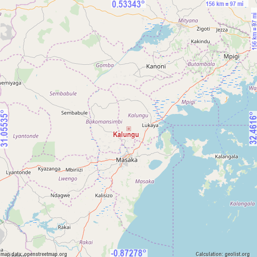
Kalungu GPS coordinates[2]
0° 10' 10.884" South, 31° 45' 30.492" East
| Map corner | latitude | longitude |
|---|---|---|
| Upper-left | 0.53343°, | 31.05535° |
| Center: | -0.16969°, | 31.75847° |
| Lower-right: | -0.87278°, | 32.4616° |
| Map W x H: | 156.4×156.4 km | = 97.2×97.2mi |
| max Lat: | 3.66088° ⇑81.5% North |
| Kalungu: | -0.16969° |
| min Lat: | ⇓18.5% South -1.28538° |
| min Long | Kalungu | max Long |
| 29.65° | 31.75847° | 34.95° |
| W 38.4%⇐ | ⇒61.6% E |
Elevation
Elevation of Kalungu is 1262 m = 4140 ft, and this is 3 m = 10 ft above average elevation for this country.
| Max E: |
4129 m = 13547 ft | 30.8% |
| Kalungu | 1262 m 4140 ft | |
| Avg. | 1259 m = 4131 ft | |
Min E: |
622 m = 2041 ft | 69.2% |
See also: Uganda elevation on elevation.city.
Geographical zone
Kalungu is located in South Torrid zone (between Equator and Tropic of Capricorn). Distance of Equator is 18.9 km =11.7 mi to North.| Distance of | km | miles | from Kalungu |
|---|---|---|---|
| Equator | 18.9 | 11.7 | to North |
| Tropic Capricorn | 2587.1 | 1607.5 | to South |
| Antarctic Circle | 7382.3 | 4587.1 | to South |
| South Pole | 9988.2 | 6206.4 | to South |


Nearby cities:
15 places around Kalungu: (largest is in red/bold)
• Bukomansimbi
17.2 km =10.7 mi,  274°
274°
• Byakabanda
74.8 km =46.5 mi,  211°
211°
• Entebbe
84 km =52.2 mi,  72°
72°
• Gombe
55.3 km =34.4 mi,  41°
41°
• Kalangala
54.1 km =33.6 mi,  106°
106°
• Kanoni
40.9 km =25.4 mi,  19°
19°
• Kasaali
54.8 km =34.1 mi, 205°
• Kyotera
56.4 km =35 mi, 208°
• Lwengo
47.6 km =29.6 mi,  234°
234°
• Lyantonde
71.7 km =44.6 mi,  248°
248°
• Masaka
18.4 km =11.4 mi,  188°
188°
• Mityana
71.6 km =44.5 mi, 24°
• Mpigi
75.7 km =47 mi,  54°
54°
• Rakai
68.4 km =42.5 mi, 206°
• Sembabule
35.1 km =21.8 mi,  287°
287°
Sources, notices
• [Note1] Compared only with cities in Uganda existing in our database
• [Src1] Map data: © OpenStreetMap contributors (CC-BY-SA)
• [Src2] Other city data from geonames.org with taken over terms of usage.
• [Src3] Geographical zone / Annual Mean Temperature by Robert A. Rohde @ Wikipedia
