Kasaali geodata
Kasaali (Central Region) is a seat of a first-order administrative division; located in Uganda in Africa/Kampala (GMT+3) time zone. In our database, there are 80 cities with bigger population. Compared to other cities in Uganda, 91.1% of cities are located further ↑North; 65.1% of cities are located further →East and 52.7% of cities have higher elevation than Kasaali. Note1
Administrative division(s):
- Level 1: Central Region
- Level 2: Kyotera
- Level 3: Kyotera
- Level 4: Kasaali


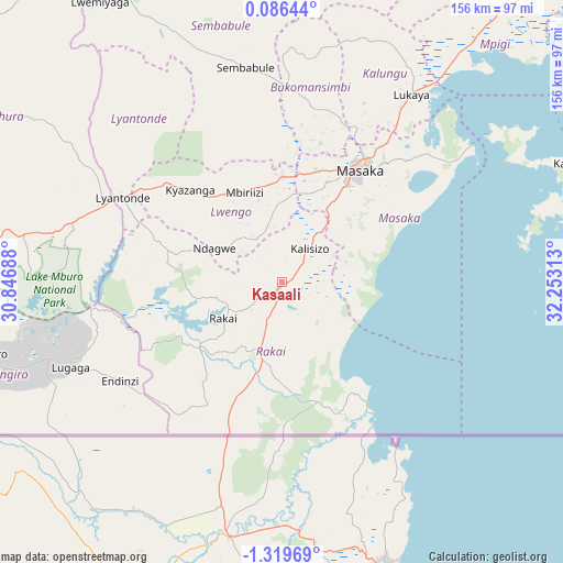
Kasaali GPS coordinates[2]
0° 37' 0.012" South, 31° 33' 0" East
| Map corner | latitude | longitude |
|---|---|---|
| Upper-left | 0.08644°, | 30.84688° |
| Center: | -0.61667°, | 31.55° |
| Lower-right: | -1.31969°, | 32.25313° |
| Map W x H: | 156.3×156.4 km | = 97.1×97.2mi |
| max Lat: | 3.66088° ⇑91.1% North |
| Kasaali: | -0.61667° |
| min Lat: | ⇓8.9% South -1.28538° |
| min Long | Kasaali | max Long |
| 29.65° | 31.55° | 34.95° |
| W 34.9%⇐ | ⇒65.1% E |
Elevation
Elevation of Kasaali is 1179 m = 3868 ft, and this is 80 m = 262 ft below average elevation for this country.
| Max E: |
4129 m = 13547 ft | 52.7% |
| Avg. | 1259 m = 4131 ft | |
| Kasaali | 1179 m = 3868 ft | |
Min E: |
622 m = 2041 ft | 47.3% |
See also: Uganda elevation on elevation.city.
Geographical zone
Kasaali is located in South Torrid zone (between Equator and Tropic of Capricorn). Distance of Equator is 68.6 km =42.6 mi to North.| Distance of | km | miles | from Kasaali |
|---|---|---|---|
| Equator | 68.6 | 42.6 | to North |
| Tropic Capricorn | 2537.4 | 1576.7 | to South |
| Antarctic Circle | 7332.6 | 4556.3 | to South |
| South Pole | 9938.5 | 6175.5 | to South |


Nearby cities:
15 places around Kasaali: (largest is in red/bold)
• Bukomansimbi
51.4 km =31.9 mi,  6°
6°
• Bwizibwera
102.5 km =63.7 mi,  271°
271°
• Byakabanda
21.2 km =13.2 mi,  228°
228°
• Isingiro
84.8 km =52.7 mi,  250°
250°
• Kalangala
82.5 km =51.3 mi,  65°
65°
• Kalungu
54.8 km =34.1 mi,  25°
25°
• Kanoni
95.6 km =59.4 mi,  22°
22°
• Kiruhura
91.3 km =56.7 mi,  300°
300°
• Kyotera
3.6 km =2.2 mi, 271°
• Lwengo
27.3 km =17 mi,  324°
324°
• Lyantonde
49.7 km =30.9 mi, 298°
• Masaka
37.5 km =23.3 mi, 33°
• Mbarara
100.2 km =62.3 mi, 270°
• Rakai
13.6 km =8.5 mi,  212°
212°
• Sembabule
60.9 km =37.8 mi,  350°
350°
Sources, notices
• [Note1] Compared only with cities in Uganda existing in our database
• [Src1] Map data: © OpenStreetMap contributors (CC-BY-SA)
• [Src2] Other city data from geonames.org with taken over terms of usage.
• [Src3] Geographical zone / Annual Mean Temperature by Robert A. Rohde @ Wikipedia
