Kumi geodata
Kumi (Eastern Region) is a seat of a second-order administrative division; located in Uganda in Africa/Kampala (GMT+3) time zone. With population of 11,400 people, there are 60 cities with bigger population in this country. Compared to other cities in Uganda, 71.2% of cities are located further ↓South; 86.3% of cities are located further ←West and 60.3% of cities have higher elevation than Kumi. Note1
Administrative division(s):
- Level 1: Eastern Region
- Level 2: Kumi District
- Level 3: Kumi County
- Level 4: Kumi County


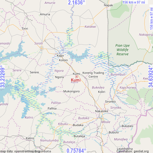
Kumi GPS coordinates[2]
1° 27' 38.988" North, 33° 56' 9.996" East
| Map corner | latitude | longitude |
|---|---|---|
| Upper-left | 2.1636°, | 33.23299° |
| Center: | 1.46083°, | 33.93611° |
| Lower-right: | 0.75784°, | 34.63924° |
| Map W x H: | 156.3×156.3 km | = 97.1×97.1mi |
| max Lat: | 3.66088° ⇑28.8% North |
| Kumi: | 1.46083° |
| min Lat: | ⇓71.2% South -1.28538° |
| min Long | Kumi | max Long |
| 29.65° | 33.93611° | 34.95° |
| W 86.3%⇐ | ⇒13.7% E |
Elevation
Elevation of Kumi is 1142 m = 3747 ft, and this is 117 m = 384 ft below average elevation for this country.
| Max E: |
4129 m = 13547 ft | 60.3% |
| Avg. | 1259 m = 4131 ft | |
| Kumi | 1142 m = 3747 ft | |
Min E: |
622 m = 2041 ft | 39.7% |
See also: Uganda elevation on elevation.city.
Geographical zone
Kumi is located in North Torrid zone (between Equator and Tropic of Cancer). Distance of Equator is 162.4 km =100.9 mi to South.| Distance of | km | miles | from Kumi |
|---|---|---|---|
| North Pole | 9844.6 | 6117.1 | to North |
| Arctic Circle | 7238.7 | 4497.9 | to North |
| Tropic Cancer | 2443.5 | 1518.3 | to North |
| Equator | 162.4 | 100.9 | to South |


Nearby cities:
15 places around Kumi: (largest is in red/bold)
• Budaka
50.8 km =31.6 mi,  181°
181°
• Bududa
66.5 km =41.3 mi,  138°
138°
• Bukedea
20.4 km =12.7 mi, 141°
• Bulambuli
59.5 km =37 mi,  123°
123°
• Butaleja
61.1 km =38 mi, 178°
• Butebo
29.7 km =18.5 mi, 182°
• Kapchorwa
57.5 km =35.7 mi,  96°
96°
• Katakwi
48 km =29.8 mi,  3°
3°
• Kibuku
48.9 km =30.4 mi,  198°
198°
• Mbale
49.8 km =30.9 mi,  147°
147°
• Ngora
18 km =11.2 mi,  259°
259°
• Pallisa
43.2 km =26.8 mi,  215°
215°
• Serere
53.6 km =33.3 mi,  273°
273°
• Sironko
43 km =26.7 mi,  126°
126°
• Soroti
45.8 km =28.5 mi,  308°
308°
Sources, notices
• [Note1] Compared only with cities in Uganda existing in our database
• [Src1] Map data: © OpenStreetMap contributors (CC-BY-SA)
• [Src2] Other city data from geonames.org with taken over terms of usage.
• [Src3] Geographical zone / Annual Mean Temperature by Robert A. Rohde @ Wikipedia
