Luwero geodata
Luwero (Central Region) is a seat of a second-order administrative division; located in Uganda in Africa/Kampala (GMT+3) time zone. With population of 28,338 people, there are 30 cities with bigger population in this country. Compared to other cities in Uganda, 52.7% of cities are located further ↓South; 51.4% of cities are located further ←West and 73.3% of cities have higher elevation than Luwero. Note1
Administrative division(s):
- Level 1: Central Region
- Level 2: Luwero District
- Level 3: Katikamu
- Level 4: Luwero Town Council


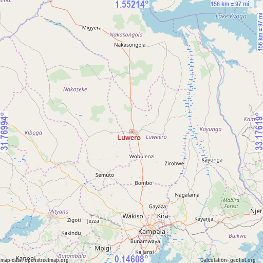
Luwero GPS coordinates[2]
0° 50' 57.012" North, 32° 28' 23.016" East
| Map corner | latitude | longitude |
|---|---|---|
| Upper-left | 1.55214°, | 31.76994° |
| Center: | 0.84917°, | 32.47306° |
| Lower-right: | 0.14608°, | 33.17619° |
| Map W x H: | 156.3×156.3 km | = 97.1×97.1mi |
| max Lat: | 3.66088° ⇑47.3% North |
| Luwero: | 0.84917° |
| min Lat: | ⇓52.7% South -1.28538° |
| min Long | Luwero | max Long |
| 29.65° | 32.47306° | 34.95° |
| W 51.4%⇐ | ⇒48.6% E |
Elevation
Elevation of Luwero is 1108 m = 3635 ft, and this is 151 m = 495 ft below average elevation for this country.
| Max E: |
4129 m = 13547 ft | 73.3% |
| Avg. | 1259 m = 4131 ft | |
| Luwero | 1108 m = 3635 ft | |
Min E: |
622 m = 2041 ft | 26.7% |
See also: Uganda elevation on elevation.city.
Geographical zone
Luwero is located in North Torrid zone (between Equator and Tropic of Cancer). Distance of Equator is 94.4 km =58.7 mi to South.| Distance of | km | miles | from Luwero |
|---|---|---|---|
| North Pole | 9912.6 | 6159.4 | to North |
| Arctic Circle | 7306.8 | 4540.2 | to North |
| Tropic Cancer | 2511.5 | 1560.6 | to North |
| Equator | 94.4 | 58.7 | to South |


Nearby cities:
15 places around Luwero: (largest is in red/bold)
• Bweyogerere
58.6 km =36.4 mi,  158°
158°
• Gombe
40.3 km =25 mi,  179°
179°
• Kajansi
70.8 km =44 mi,  174°
174°
• Kampala
60.5 km =37.6 mi, 168°
• Kampala Central Division
59.4 km =36.9 mi, 169°
• Kayunga
49 km =30.4 mi,  109°
109°
• Kireka
59.1 km =36.7 mi, 160°
• Mityana
69.4 km =43.1 mi,  226°
226°
• Mpigi
71.6 km =44.5 mi,  194°
194°
• Mukono
63.4 km =39.4 mi,  150°
150°
• Nakaseke
14.6 km =9.1 mi,  222°
222°
• Nakasongola
51.1 km =31.8 mi,  357°
357°
• Namasuba
18.7 km =11.6 mi,  197°
197°
• Wakiso
49.5 km =30.8 mi, 181°
• Wobulenzi
14.1 km =8.8 mi, 162°
Sources, notices
• [Note1] Compared only with cities in Uganda existing in our database
• [Src1] Map data: © OpenStreetMap contributors (CC-BY-SA)
• [Src2] Other city data from geonames.org with taken over terms of usage.
• [Src3] Geographical zone / Annual Mean Temperature by Robert A. Rohde @ Wikipedia
