Nakasongola geodata
Nakasongola (Central Region) is a seat of a second-order administrative division; located in Uganda in Africa/Kampala (GMT+3) time zone. With population of 6,921 people, there are 71 cities with bigger population in this country. Compared to other cities in Uganda, 67.1% of cities are located further ↓South; 50% of cities are located further ←West and 79.5% of cities have higher elevation than Nakasongola. Note1
Administrative division(s):
- Level 1: Central Region
- Level 2: Nakasongola District
- Level 3: Buruli
- Level 4: Nakasongola Town Council


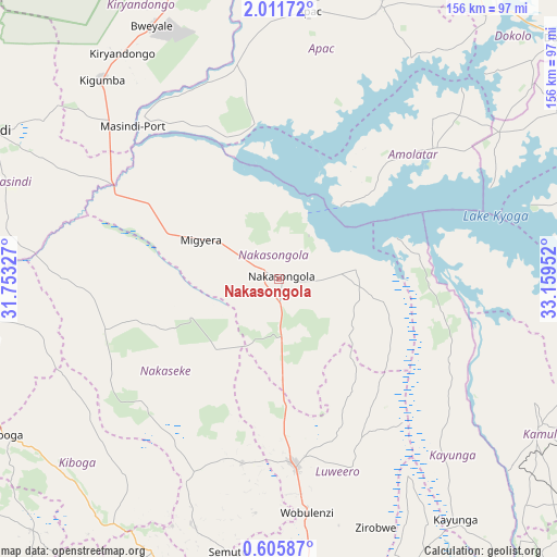
Nakasongola GPS coordinates[2]
1° 18' 32.004" North, 32° 27' 23.004" East
| Map corner | latitude | longitude |
|---|---|---|
| Upper-left | 2.01172°, | 31.75327° |
| Center: | 1.30889°, | 32.45639° |
| Lower-right: | 0.60587°, | 33.15952° |
| Map W x H: | 156.3×156.3 km | = 97.1×97.1mi |
| max Lat: | 3.66088° ⇑32.9% North |
| Nakasongola: | 1.30889° |
| min Lat: | ⇓67.1% South -1.28538° |
| min Long | Nakasongola | max Long |
| 29.65° | 32.45639° | 34.95° |
| W 50%⇐ | ⇒50% E |
Elevation
Elevation of Nakasongola is 1091 m = 3579 ft, and this is 168 m = 551 ft below average elevation for this country.
| Max E: |
4129 m = 13547 ft | 79.5% |
| Avg. | 1259 m = 4131 ft | |
| Nakasongola | 1091 m = 3579 ft | |
Min E: |
622 m = 2041 ft | 20.5% |
See also: Uganda elevation on elevation.city.
Geographical zone
Nakasongola is located in North Torrid zone (between Equator and Tropic of Cancer). Distance of Equator is 145.5 km =90.4 mi to South.| Distance of | km | miles | from Nakasongola |
|---|---|---|---|
| North Pole | 9861.5 | 6127.7 | to North |
| Arctic Circle | 7255.6 | 4508.4 | to North |
| Tropic Cancer | 2460.4 | 1528.8 | to North |
| Equator | 145.5 | 90.4 | to South |


Nearby cities:
15 places around Nakasongola: (largest is in red/bold)
• Amolatar
54.6 km =33.9 mi,  51°
51°
• Apac
74.7 km =46.4 mi,  7°
7°
• Buyende
79.6 km =49.5 mi,  102°
102°
• Gombe
91.4 km =56.8 mi,  178°
178°
• Kaberamaido
91.6 km =56.9 mi,  58°
58°
• Kamuli
84 km =52.2 mi,  118°
118°
• Kayunga
82.8 km =51.4 mi,  144°
144°
• Kiboga
87.5 km =54.4 mi,  240°
240°
• Kiryandongo
76.8 km =47.7 mi,  325°
325°
• Kyankwanzi
73.9 km =45.9 mi,  260°
260°
• Luwero
51.1 km =31.8 mi, 177°
• Masindi Port
59.6 km =37 mi,  316°
316°
• Nakaseke
62.5 km =38.8 mi,  187°
187°
• Namasuba
69 km =42.9 mi, 183°
• Wobulenzi
64.8 km =40.3 mi,  174°
174°
Sources, notices
• [Note1] Compared only with cities in Uganda existing in our database
• [Src1] Map data: © OpenStreetMap contributors (CC-BY-SA)
• [Src2] Other city data from geonames.org with taken over terms of usage.
• [Src3] Geographical zone / Annual Mean Temperature by Robert A. Rohde @ Wikipedia
