White Hall geodata
White Hall (Alabama) is a populated place; located in United States in America/Chicago (GMT-5) time zone. With population of 811 people, there are 17710 cities with bigger population in this country. Compared to other cities in United States, 87.7% of cities are located further ↑North; 51% of cities are located further ←West and 76.9% of cities have higher elevation than White Hall. Note1


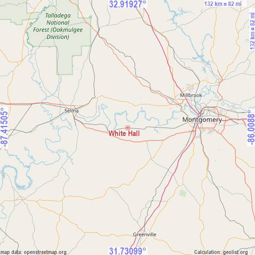
White Hall GPS coordinates[2]
32° 19' 37.488" North, 86° 42' 42.912" West
| Map corner | latitude | longitude |
|---|---|---|
| Upper-left | 32.91927°, | -87.41505° |
| Center: | 32.32708°, | -86.71192° |
| Lower-right: | 31.73099°, | -86.0088° |
| Map W x H: | 132.1×132.1 km | = 82.1×82.1mi |
| max Lat: | 71.29058° ⇑87.7% North |
| White Hall: | 32.32708° |
| min Lat: | ⇓12.3% South 19.06759° |
| min Long | White Hall | max Long |
| -171.73463° | -86.71192° | -66.98998° |
| W 51%⇐ | ⇒49% E |
Elevation
Elevation of White Hall is 61 m = 200 ft, and this is 233.8 m = 767 ft below average elevation for this country.
| Max E: |
3189 m = 10463 ft | 76.9% |
| Avg. | 294.8 m = 967 ft | |
| White Hall | 61 m = 200 ft | |
Min E: |
-60 m = -197 ft | 23.1% |
See also: United States elevation on elevation.city.
Geographical zone
White Hall is located in North temperate zone (between Tropic of Cancer and the Arctic Circle). Distance of this Northern Tropic circle is 988.5 km =614.2 mi to South.| Distance of | km | miles | from White Hall |
|---|---|---|---|
| North Pole | 6412.6 | 3984.6 | to North |
| Arctic Circle | 3806.7 | 2365.4 | to North |
| Tropic Cancer | 988.5 | 614.2 | to South |
| Equator | 3594.4 | 2233.5 | to South |


Nearby cities:
15 places around White Hall: (largest is in red/bold)
• Autaugaville
13 km =8.1 mi,  24°
24°
• Coosada
40.5 km =25.2 mi,  61°
61°
• Deatsville
43.1 km =26.8 mi,  43°
43°
• Elmore
44.1 km =27.4 mi, 57°
• Fort Deposit
40.1 km =24.9 mi,  161°
161°
• Hayneville
20.2 km =12.6 mi,  142°
142°
• Marbury
47.3 km =29.4 mi,  28°
28°
• Millbrook
37 km =23 mi, 62°
• Montgomery
38.9 km =24.2 mi,  83°
83°
• Mosses
17.4 km =10.8 mi,  167°
167°
• Pine Level
36.7 km =22.8 mi, 39°
• Prattville
28.2 km =17.5 mi, 57°
• Selma
30.4 km =18.9 mi,  287°
287°
• Selmont-West Selmont
28.3 km =17.6 mi,  281°
281°
• Valley Grande
32.8 km =20.4 mi,  308°
308°
Sources, notices
• [Note1] Compared only with cities in United States existing in our database
• [Src1] Map data: © OpenStreetMap contributors (CC-BY-SA)
• [Src2] Other city data from geonames.org with taken over terms of usage.
• [Src3] Geographical zone / Annual Mean Temperature by Robert A. Rohde @ Wikipedia
