Reform geodata
Reform (Alabama) is a populated place; located in United States in America/Chicago (GMT-5) time zone. With population of 1,632 people, there are 13160 cities with bigger population in this country. Compared to other cities in United States, 83.7% of cities are located further ↑North; 52.9% of cities are located further →East and 74.7% of cities have higher elevation than Reform. Note1


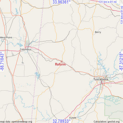
Reform GPS coordinates[2]
33° 22' 42.42" North, 88° 0' 55.08" West
| Map corner | latitude | longitude |
|---|---|---|
| Upper-left | 33.96361°, | -88.71843° |
| Center: | 33.37845°, | -88.0153° |
| Lower-right: | 32.78933°, | -87.31218° |
| Map W x H: | 130.6×130.6 km | = 81.2×81.2mi |
| max Lat: | 71.29058° ⇑83.7% North |
| Reform: | 33.37845° |
| min Lat: | ⇓16.3% South 19.06759° |
| min Long | Reform | max Long |
| -171.73463° | -88.0153° | -66.98998° |
| W 47.1%⇐ | ⇒52.9% E |
Elevation
Elevation of Reform is 73 m = 240 ft, and this is 221.8 m = 728 ft below average elevation for this country.
| Max E: |
3189 m = 10463 ft | 74.7% |
| Avg. | 294.8 m = 967 ft | |
| Reform | 73 m = 240 ft | |
Min E: |
-60 m = -197 ft | 25.3% |
See also: United States elevation on elevation.city.
Geographical zone
Reform is located in North temperate zone (between Tropic of Cancer and the Arctic Circle). Distance of this Northern Tropic circle is 1105.4 km =686.9 mi to South.| Distance of | km | miles | from Reform |
|---|---|---|---|
| North Pole | 6295.7 | 3912 | to North |
| Arctic Circle | 3689.8 | 2292.7 | to North |
| Tropic Cancer | 1105.4 | 686.9 | to South |
| Equator | 3711.3 | 2306.1 | to South |


Nearby cities:
15 places around Reform: (largest is in red/bold)
• Aliceville
30.4 km =18.9 mi,  204°
204°
• Berry
49.6 km =30.8 mi,  50°
50°
• Caledonia
44.4 km =27.6 mi,  319°
319°
• Carrollton
14.9 km =9.3 mi,  209°
209°
• Coker
33.8 km =21 mi,  115°
115°
• Columbus
40.4 km =25.1 mi,  288°
288°
• Columbus Air Force Base
49.3 km =30.6 mi,  304°
304°
• Fayette
38.1 km =23.7 mi,  26°
26°
• Gordo
12.3 km =7.6 mi, 121°
• Millport
21.5 km =13.4 mi,  343°
343°
• New Hope
30.6 km =19 mi, 289°
• Northport
44 km =27.3 mi,  112°
112°
• Pickensville
28.8 km =17.9 mi,  234°
234°
• Tuscaloosa
45.5 km =28.3 mi, 114°
• Vernon
43 km =26.7 mi,  348°
348°
Sources, notices
• [Note1] Compared only with cities in United States existing in our database
• [Src1] Map data: © OpenStreetMap contributors (CC-BY-SA)
• [Src2] Other city data from geonames.org with taken over terms of usage.
• [Src3] Geographical zone / Annual Mean Temperature by Robert A. Rohde @ Wikipedia
