Tuscaloosa geodata
Tuscaloosa (Alabama) is a seat of a second-order administrative division; located in United States in America/Chicago (GMT-5) time zone. With population of 98,332 people, there are 360 cities with bigger population in this country. Compared to other cities in United States, 84.3% of cities are located further ↑North; 50.9% of cities are located further →East and 75.5% of cities have higher elevation than Tuscaloosa. Note1


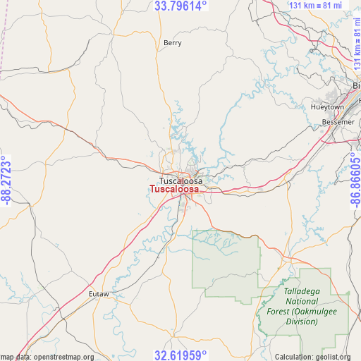
Tuscaloosa GPS coordinates[2]
33° 12' 35.424" North, 87° 34' 9.012" West
| Map corner | latitude | longitude |
|---|---|---|
| Upper-left | 33.79614°, | -88.2723° |
| Center: | 33.20984°, | -87.56917° |
| Lower-right: | 32.61959°, | -86.86605° |
| Map W x H: | 130.8×130.8 km | = 81.3×81.3mi |
| max Lat: | 71.29058° ⇑84.3% North |
| Tuscaloosa: | 33.20984° |
| min Lat: | ⇓15.7% South 19.06759° |
| min Long | Tuscaloosa | max Long |
| -171.73463° | -87.56917° | -66.98998° |
| W 49.1%⇐ | ⇒50.9% E |
Elevation
Elevation of Tuscaloosa is 69 m = 226 ft, and this is 225.8 m = 741 ft below average elevation for this country.
| Max E: |
3189 m = 10463 ft | 75.5% |
| Avg. | 294.8 m = 967 ft | |
| Tuscaloosa | 69 m = 226 ft | |
Min E: |
-60 m = -197 ft | 24.5% |
See also: Tuscaloosa elevation on elevation.city.
Geographical zone
Tuscaloosa is located in North temperate zone (between Tropic of Cancer and the Arctic Circle). Distance of this Northern Tropic circle is 1086.7 km =675.2 mi to South.| Distance of | km | miles | from Tuscaloosa |
|---|---|---|---|
| North Pole | 6314.5 | 3923.6 | to North |
| Arctic Circle | 3708.6 | 2304.4 | to North |
| Tropic Cancer | 1086.7 | 675.2 | to South |
| Equator | 3692.6 | 2294.5 | to South |


Nearby cities:
15 places around Tuscaloosa: (largest is in red/bold)
• Brent
48.4 km =30.1 mi,  128°
128°
• Brookwood
23.7 km =14.7 mi,  77°
77°
• Carrollton
49.2 km =30.6 mi,  276°
276°
• Coaling
22 km =13.7 mi,  104°
104°
• Coker
11.7 km =7.3 mi,  289°
289°
• Gordo
33.4 km =20.8 mi, 291°
• Holt
8.3 km =5.2 mi,  71°
71°
• Lake View
40.9 km =25.4 mi, 78°
• Moundville
24.3 km =15.1 mi,  193°
193°
• North Bibb
38.7 km =24 mi,  90°
90°
• Northport
2.3 km =1.4 mi,  340°
340°
• Reform
45.5 km =28.3 mi, 294°
• Vance
31.5 km =19.6 mi, 97°
• West Blocton
42.6 km =26.5 mi, 103°
• Woodstock
39 km =24.2 mi, 90°
Sources, notices
• [Note1] Compared only with cities in United States existing in our database
• [Src1] Map data: © OpenStreetMap contributors (CC-BY-SA)
• [Src2] Other city data from geonames.org with taken over terms of usage.
• [Src3] Geographical zone / Annual Mean Temperature by Robert A. Rohde @ Wikipedia
