Woodville geodata
Woodville (Alabama) is a populated place; located in United States in America/Chicago (GMT-5) time zone. With population of 735 people, there are 18355 cities with bigger population in this country. Compared to other cities in United States, 77.2% of cities are located further ↑North; 52.1% of cities are located further ←West and 54.2% of cities have higher elevation than Woodville. Note1


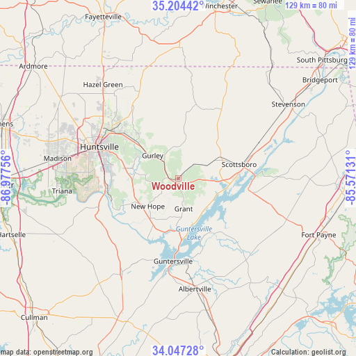
Woodville GPS coordinates[2]
34° 37' 40.332" North, 86° 16' 27.948" West
| Map corner | latitude | longitude |
|---|---|---|
| Upper-left | 35.20442°, | -86.97756° |
| Center: | 34.62787°, | -86.27443° |
| Lower-right: | 34.04728°, | -85.57131° |
| Map W x H: | 128.7×128.7 km | = 80×80mi |
| max Lat: | 71.29058° ⇑77.2% North |
| Woodville: | 34.62787° |
| min Lat: | ⇓22.8% South 19.06759° |
| min Long | Woodville | max Long |
| -171.73463° | -86.27443° | -66.98998° |
| W 52.1%⇐ | ⇒47.9% E |
Elevation
Elevation of Woodville is 183 m = 600 ft, and this is 111.8 m = 367 ft below average elevation for this country.
| Max E: |
3189 m = 10463 ft | 54.2% |
| Avg. | 294.8 m = 967 ft | |
| Woodville | 183 m = 600 ft | |
Min E: |
-60 m = -197 ft | 45.8% |
See also: United States elevation on elevation.city.
Geographical zone
Woodville is located in North temperate zone (between Tropic of Cancer and the Arctic Circle). Distance of this Northern Tropic circle is 1244.3 km =773.2 mi to South.| Distance of | km | miles | from Woodville |
|---|---|---|---|
| North Pole | 6156.8 | 3825.7 | to North |
| Arctic Circle | 3550.9 | 2206.4 | to North |
| Tropic Cancer | 1244.3 | 773.2 | to South |
| Equator | 3850.3 | 2392.5 | to South |


Nearby cities:
15 places around Woodville: (largest is in red/bold)
• Grant
11.2 km =7 mi,  170°
170°
• Guntersville
30 km =18.6 mi,  183°
183°
• Gurley
12.4 km =7.7 mi,  311°
311°
• Hollywood
29.6 km =18.4 mi,  68°
68°
• Huntsville
30.7 km =19.1 mi,  291°
291°
• Meridianville
36.9 km =22.9 mi, 312°
• Moores Mill
32.8 km =20.4 mi,  317°
317°
• New Hope
14.9 km =9.3 mi,  227°
227°
• New Market
34.4 km =21.4 mi,  335°
335°
• Owens Cross Roads
17.4 km =10.8 mi,  255°
255°
• Powell
36.4 km =22.6 mi,  107°
107°
• Redstone Arsenal
34.7 km =21.6 mi,  280°
280°
• Scottsboro
22.5 km =14 mi,  77°
77°
• Section
26.9 km =16.7 mi,  101°
101°
• Skyline
25.3 km =15.7 mi,  35°
35°
Sources, notices
• [Note1] Compared only with cities in United States existing in our database
• [Src1] Map data: © OpenStreetMap contributors (CC-BY-SA)
• [Src2] Other city data from geonames.org with taken over terms of usage.
• [Src3] Geographical zone / Annual Mean Temperature by Robert A. Rohde @ Wikipedia
