Sylacauga geodata
Sylacauga (Alabama) is a populated place; located in United States in America/Chicago (GMT-5) time zone. With population of 12,657 people, there are 3741 cities with bigger population in this country. Compared to other cities in United States, 84.5% of cities are located further ↑North; 52.2% of cities are located further ←West and 57.3% of cities have higher elevation than Sylacauga. Note1


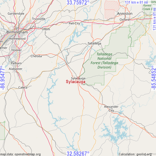
Sylacauga GPS coordinates[2]
33° 10' 23.412" North, 86° 15' 5.904" West
| Map corner | latitude | longitude |
|---|---|---|
| Upper-left | 33.75972°, | -86.95477° |
| Center: | 33.17317°, | -86.25164° |
| Lower-right: | 32.58267°, | -85.54852° |
| Map W x H: | 130.9×130.9 km | = 81.3×81.3mi |
| max Lat: | 71.29058° ⇑84.5% North |
| Sylacauga: | 33.17317° |
| min Lat: | ⇓15.5% South 19.06759° |
| min Long | Sylacauga | max Long |
| -171.73463° | -86.25164° | -66.98998° |
| W 52.2%⇐ | ⇒47.8% E |
Elevation
Elevation of Sylacauga is 169 m = 554 ft, and this is 125.8 m = 413 ft below average elevation for this country.
| Max E: |
3189 m = 10463 ft | 57.3% |
| Avg. | 294.8 m = 967 ft | |
| Sylacauga | 169 m = 554 ft | |
Min E: |
-60 m = -197 ft | 42.7% |
See also: United States elevation on elevation.city.
Geographical zone
Sylacauga is located in North temperate zone (between Tropic of Cancer and the Arctic Circle). Distance of this Northern Tropic circle is 1082.6 km =672.7 mi to South.| Distance of | km | miles | from Sylacauga |
|---|---|---|---|
| North Pole | 6318.6 | 3926.2 | to North |
| Arctic Circle | 3712.7 | 2307 | to North |
| Tropic Cancer | 1082.6 | 672.7 | to South |
| Equator | 3688.5 | 2291.9 | to South |


Nearby cities:
15 places around Sylacauga: (largest is in red/bold)
• Childersburg
15.1 km =9.4 mi,  320°
320°
• Fayetteville
14.7 km =9.1 mi,  257°
257°
• Goodwater
22 km =13.7 mi,  122°
122°
• Harpersville
25.7 km =16 mi, 317°
• Hissop
32.5 km =20.2 mi,  163°
163°
• Hollins
11.7 km =7.3 mi, 121°
• Mignon
1.4 km =0.9 mi, 322°
• Oak Grove
4.9 km =3 mi,  294°
294°
• Rockford
31.7 km =19.7 mi,  174°
174°
• Shelby
31.7 km =19.7 mi, 257°
• Stewartville
10.5 km =6.5 mi,  176°
176°
• Talladega
32.2 km =20 mi,  24°
24°
• Vincent
27.8 km =17.3 mi,  327°
327°
• Westover
32.9 km =20.4 mi,  306°
306°
• Wilsonville
22.6 km =14 mi, 287°
Sources, notices
• [Note1] Compared only with cities in United States existing in our database
• [Src1] Map data: © OpenStreetMap contributors (CC-BY-SA)
• [Src2] Other city data from geonames.org with taken over terms of usage.
• [Src3] Geographical zone / Annual Mean Temperature by Robert A. Rohde @ Wikipedia
