Hayneville geodata
Hayneville (Alabama) is a seat of a second-order administrative division; located in United States in America/Chicago (GMT-5) time zone. With population of 862 people, there are 17264 cities with bigger population in this country. Compared to other cities in United States, 88.1% of cities are located further ↑North; 51.4% of cities are located further ←West and 73.9% of cities have higher elevation than Hayneville. Note1


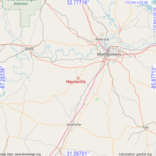
Hayneville GPS coordinates[2]
32° 11' 2.508" North, 86° 34' 48.9" West
| Map corner | latitude | longitude |
|---|---|---|
| Upper-left | 32.77716°, | -87.28338° |
| Center: | 32.18403°, | -86.58025° |
| Lower-right: | 31.58701°, | -85.87713° |
| Map W x H: | 132.3×132.3 km | = 82.2×82.2mi |
| max Lat: | 71.29058° ⇑88.1% North |
| Hayneville: | 32.18403° |
| min Lat: | ⇓11.9% South 19.06759° |
| min Long | Hayneville | max Long |
| -171.73463° | -86.58025° | -66.98998° |
| W 51.4%⇐ | ⇒48.6% E |
Elevation
Elevation of Hayneville is 78 m = 256 ft, and this is 216.8 m = 711 ft below average elevation for this country.
| Max E: |
3189 m = 10463 ft | 73.9% |
| Avg. | 294.8 m = 967 ft | |
| Hayneville | 78 m = 256 ft | |
Min E: |
-60 m = -197 ft | 26.1% |
See also: United States elevation on elevation.city.
Geographical zone
Hayneville is located in North temperate zone (between Tropic of Cancer and the Arctic Circle). Distance of this Northern Tropic circle is 972.6 km =604.3 mi to South.| Distance of | km | miles | from Hayneville |
|---|---|---|---|
| North Pole | 6428.5 | 3994.5 | to North |
| Arctic Circle | 3822.6 | 2375.3 | to North |
| Tropic Cancer | 972.6 | 604.3 | to South |
| Equator | 3578.5 | 2223.6 | to South |


Nearby cities:
15 places around Hayneville: (largest is in red/bold)
• Autaugaville
28.7 km =17.8 mi,  345°
345°
• Coosada
42 km =26.1 mi,  33°
33°
• Elmore
46.7 km =29 mi, 32°
• Fort Deposit
22.2 km =13.8 mi,  179°
179°
• Greenville
39.6 km =24.6 mi,  185°
185°
• Millbrook
38.8 km =24.1 mi, 31°
• Montgomery
33.3 km =20.7 mi,  52°
52°
• Mosses
8.7 km =5.4 mi,  263°
263°
• Pike Road
46.2 km =28.7 mi,  76°
76°
• Pine Level
45.7 km =28.4 mi,  13°
13°
• Pisgah
48.2 km =30 mi,  115°
115°
• Prattville
33.1 km =20.6 mi,  19°
19°
• Selmont-West Selmont
45.6 km =28.3 mi,  298°
298°
• Taylor
40.1 km =24.9 mi,  125°
125°
• White Hall
20.2 km =12.6 mi,  322°
322°
Sources, notices
• [Note1] Compared only with cities in United States existing in our database
• [Src1] Map data: © OpenStreetMap contributors (CC-BY-SA)
• [Src2] Other city data from geonames.org with taken over terms of usage.
• [Src3] Geographical zone / Annual Mean Temperature by Robert A. Rohde @ Wikipedia
