Fort Deposit geodata
Fort Deposit (Alabama) is a populated place; located in United States in America/Chicago (GMT-5) time zone. With population of 1,240 people, there are 14907 cities with bigger population in this country. Compared to other cities in United States, 88.6% of cities are located further ↑North; 51.4% of cities are located further ←West and 62.1% of cities have higher elevation than Fort Deposit. Note1


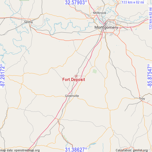
Fort Deposit GPS coordinates[2]
31° 59' 4.524" North, 86° 34' 42.924" West
| Map corner | latitude | longitude |
|---|---|---|
| Upper-left | 32.57903°, | -87.28172° |
| Center: | 31.98459°, | -86.57859° |
| Lower-right: | 31.38627°, | -85.87547° |
| Map W x H: | 132.6×132.6 km | = 82.4×82.4mi |
| max Lat: | 71.29058° ⇑88.6% North |
| Fort Deposit: | 31.98459° |
| min Lat: | ⇓11.4% South 19.06759° |
| min Long | Fort Deposit | max Long |
| -171.73463° | -86.57859° | -66.98998° |
| W 51.4%⇐ | ⇒48.6% E |
Elevation
Elevation of Fort Deposit is 144 m = 472 ft, and this is 150.8 m = 495 ft below average elevation for this country.
| Max E: |
3189 m = 10463 ft | 62.1% |
| Avg. | 294.8 m = 967 ft | |
| Fort Deposit | 144 m = 472 ft | |
Min E: |
-60 m = -197 ft | 37.9% |
See also: United States elevation on elevation.city.
Geographical zone
Fort Deposit is located in North temperate zone (between Tropic of Cancer and the Arctic Circle). Distance of this Northern Tropic circle is 950.4 km =590.6 mi to South.| Distance of | km | miles | from Fort Deposit |
|---|---|---|---|
| North Pole | 6450.7 | 4008.3 | to North |
| Arctic Circle | 3844.8 | 2389 | to North |
| Tropic Cancer | 950.4 | 590.6 | to South |
| Equator | 3556.4 | 2209.8 | to South |


Nearby cities:
15 places around Fort Deposit: (largest is in red/bold)
• Autaugaville
50.5 km =31.4 mi,  351°
351°
• Brantley
54.1 km =33.6 mi,  145°
145°
• Georgiana
41.6 km =25.8 mi,  201°
201°
• Greenville
17.6 km =10.9 mi,  192°
192°
• Hayneville
22.2 km =13.8 mi,  359°
359°
• Joquin
44.9 km =27.9 mi,  119°
119°
• Luverne
42.1 km =26.2 mi,  135°
135°
• McKenzie
50.8 km =31.6 mi, 194°
• Montgomery
49.9 km =31 mi,  31°
31°
• Mosses
22.9 km =14.2 mi,  337°
337°
• Pike Road
55.8 km =34.7 mi,  53°
53°
• Pisgah
43.4 km =27 mi,  88°
88°
• Prattville
54.5 km =33.9 mi,  11°
11°
• Taylor
32.6 km =20.3 mi, 91°
• White Hall
40.1 km =24.9 mi, 341°
Sources, notices
• [Note1] Compared only with cities in United States existing in our database
• [Src1] Map data: © OpenStreetMap contributors (CC-BY-SA)
• [Src2] Other city data from geonames.org with taken over terms of usage.
• [Src3] Geographical zone / Annual Mean Temperature by Robert A. Rohde @ Wikipedia
