El Dorado geodata
El Dorado (Arkansas) is a seat of a second-order administrative division; located in United States in America/Chicago (GMT-5) time zone. With population of 18,386 people, there are 2728 cities with bigger population in this country. Compared to other cities in United States, 84.3% of cities are located further ↑North; 65.6% of cities are located further →East and 73% of cities have higher elevation than El Dorado. Note1


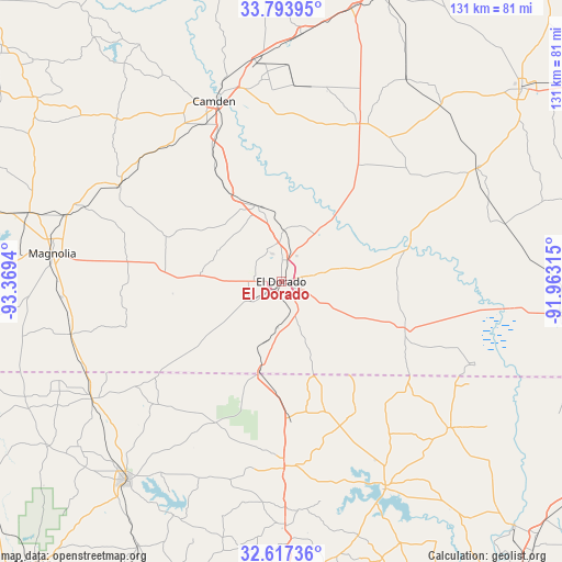
El Dorado GPS coordinates[2]
33° 12' 27.468" North, 92° 39' 58.572" West
| Map corner | latitude | longitude |
|---|---|---|
| Upper-left | 33.79395°, | -93.3694° |
| Center: | 33.20763°, | -92.66627° |
| Lower-right: | 32.61736°, | -91.96315° |
| Map W x H: | 130.8×130.8 km | = 81.3×81.3mi |
| max Lat: | 71.29058° ⇑84.3% North |
| El Dorado: | 33.20763° |
| min Lat: | ⇓15.7% South 19.06759° |
| min Long | El Dorado | max Long |
| -171.73463° | -92.66627° | -66.98998° |
| W 34.4%⇐ | ⇒65.6% E |
Elevation
Elevation of El Dorado is 83 m = 272 ft, and this is 211.8 m = 695 ft below average elevation for this country.
| Max E: |
3189 m = 10463 ft | 73% |
| Avg. | 294.8 m = 967 ft | |
| El Dorado | 83 m = 272 ft | |
Min E: |
-60 m = -197 ft | 27% |
See also: United States elevation on elevation.city.
Geographical zone
El Dorado is located in North temperate zone (between Tropic of Cancer and the Arctic Circle). Distance of this Northern Tropic circle is 1086.4 km =675.1 mi to South.| Distance of | km | miles | from El Dorado |
|---|---|---|---|
| North Pole | 6314.7 | 3923.8 | to North |
| Arctic Circle | 3708.8 | 2304.5 | to North |
| Tropic Cancer | 1086.4 | 675.1 | to South |
| Equator | 3692.3 | 2294.3 | to South |


Nearby cities:
15 places around El Dorado: (largest is in red/bold)
• Bernice
42.9 km =26.7 mi,  178°
178°
• Camden
44.7 km =27.8 mi,  339°
339°
• East Camden
45 km =28 mi,  351°
351°
• Hampton
41 km =25.5 mi,  26°
26°
• Haynesville
51.9 km =32.2 mi,  238°
238°
• Hermitage
52.9 km =32.9 mi,  59°
59°
• Huttig
48.8 km =30.3 mi,  112°
112°
• Junction City
22 km =13.7 mi,  194°
194°
• Junction City
22.2 km =13.8 mi, 194°
• Magnolia
53.7 km =33.4 mi,  277°
277°
• Marion
52.2 km =32.4 mi,  130°
130°
• Norphlet
12 km =7.5 mi,  1°
1°
• Smackover
18.3 km =11.4 mi, 342°
• Stephens
43.8 km =27.2 mi,  301°
301°
• Strong
32.8 km =20.4 mi, 109°
Sources, notices
• [Note1] Compared only with cities in United States existing in our database
• [Src1] Map data: © OpenStreetMap contributors (CC-BY-SA)
• [Src2] Other city data from geonames.org with taken over terms of usage.
• [Src3] Geographical zone / Annual Mean Temperature by Robert A. Rohde @ Wikipedia
