Stephens geodata
Stephens (Arkansas) is a populated place; located in United States in America/Chicago (GMT-5) time zone. With population of 827 people, there are 17545 cities with bigger population in this country. Compared to other cities in United States, 83.6% of cities are located further ↑North; 66.4% of cities are located further →East and 73.7% of cities have higher elevation than Stephens. Note1
Administrative division(s):
- Level 1: Arkansas
- Level 2: Ouachita County
- Level 3: Township of Smackover


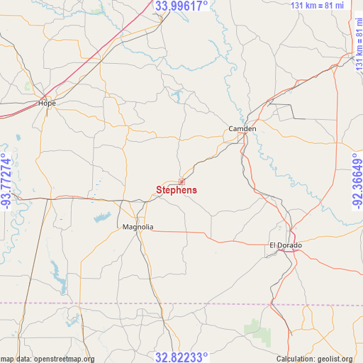
Stephens GPS coordinates[2]
33° 24' 40.428" North, 93° 4' 10.596" West
| Map corner | latitude | longitude |
|---|---|---|
| Upper-left | 33.99617°, | -93.77274° |
| Center: | 33.41123°, | -93.06961° |
| Lower-right: | 32.82233°, | -92.36649° |
| Map W x H: | 130.5×130.5 km | = 81.1×81.1mi |
| max Lat: | 71.29058° ⇑83.6% North |
| Stephens: | 33.41123° |
| min Lat: | ⇓16.4% South 19.06759° |
| min Long | Stephens | max Long |
| -171.73463° | -93.06961° | -66.98998° |
| W 33.6%⇐ | ⇒66.4% E |
Elevation
Elevation of Stephens is 79 m = 259 ft, and this is 215.8 m = 708 ft below average elevation for this country.
| Max E: |
3189 m = 10463 ft | 73.7% |
| Avg. | 294.8 m = 967 ft | |
| Stephens | 79 m = 259 ft | |
Min E: |
-60 m = -197 ft | 26.3% |
See also: United States elevation on elevation.city.
Geographical zone
Stephens is located in North temperate zone (between Tropic of Cancer and the Arctic Circle). Distance of this Northern Tropic circle is 1109.1 km =689.2 mi to South.| Distance of | km | miles | from Stephens |
|---|---|---|---|
| North Pole | 6292.1 | 3909.7 | to North |
| Arctic Circle | 3686.2 | 2290.5 | to North |
| Tropic Cancer | 1109.1 | 689.2 | to South |
| Equator | 3715 | 2308.4 | to South |


Nearby cities:
15 places around Stephens: (largest is in red/bold)
• Bearden
54.6 km =33.9 mi,  50°
50°
• Camden
29.1 km =18.1 mi, 48°
• East Camden
37.6 km =23.4 mi, 54°
• El Dorado
43.8 km =27.2 mi,  121°
121°
• Haynesville
50.4 km =31.3 mi,  187°
187°
• Junction City
54.4 km =33.8 mi,  143°
143°
• Junction City
54.6 km =33.9 mi, 144°
• Lewisville
47.5 km =29.5 mi,  262°
262°
• Magnolia
22.5 km =14 mi,  224°
224°
• Norphlet
39.2 km =24.4 mi,  105°
105°
• Prescott
52.2 km =32.4 mi,  326°
326°
• Smackover
32.4 km =20.1 mi,  99°
99°
• Stamps
39.8 km =24.7 mi, 262°
• Taylor
50.2 km =31.2 mi,  226°
226°
• Waldo
22 km =13.7 mi,  252°
252°
Sources, notices
• [Note1] Compared only with cities in United States existing in our database
• [Src1] Map data: © OpenStreetMap contributors (CC-BY-SA)
• [Src2] Other city data from geonames.org with taken over terms of usage.
• [Src3] Geographical zone / Annual Mean Temperature by Robert A. Rohde @ Wikipedia
