Rison geodata
Rison (Arkansas) is a seat of a second-order administrative division; located in United States in America/Chicago (GMT-5) time zone. With population of 1,282 people, there are 14675 cities with bigger population in this country. Compared to other cities in United States, 80.5% of cities are located further ↑North; 64.6% of cities are located further →East and 72.3% of cities have higher elevation than Rison. Note1


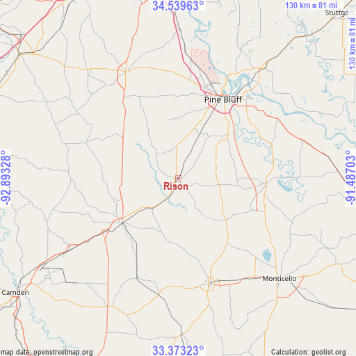
Rison GPS coordinates[2]
33° 57' 30.348" North, 92° 11' 24.54" West
| Map corner | latitude | longitude |
|---|---|---|
| Upper-left | 34.53963°, | -92.89328° |
| Center: | 33.95843°, | -92.19015° |
| Lower-right: | 33.37323°, | -91.48703° |
| Map W x H: | 129.7×129.7 km | = 80.6×80.6mi |
| max Lat: | 71.29058° ⇑80.5% North |
| Rison: | 33.95843° |
| min Lat: | ⇓19.5% South 19.06759° |
| min Long | Rison | max Long |
| -171.73463° | -92.19015° | -66.98998° |
| W 35.4%⇐ | ⇒64.6% E |
Elevation
Elevation of Rison is 87 m = 285 ft, and this is 207.8 m = 682 ft below average elevation for this country.
| Max E: |
3189 m = 10463 ft | 72.3% |
| Avg. | 294.8 m = 967 ft | |
| Rison | 87 m = 285 ft | |
Min E: |
-60 m = -197 ft | 27.7% |
See also: United States elevation on elevation.city.
Geographical zone
Rison is located in North temperate zone (between Tropic of Cancer and the Arctic Circle). Distance of this Northern Tropic circle is 1169.9 km =726.9 mi to South.| Distance of | km | miles | from Rison |
|---|---|---|---|
| North Pole | 6231.2 | 3871.9 | to North |
| Arctic Circle | 3625.4 | 2252.7 | to North |
| Tropic Cancer | 1169.9 | 726.9 | to South |
| Equator | 3775.8 | 2346.2 | to South |


Nearby cities:
15 places around Rison: (largest is in red/bold)
• Altheimer
51 km =31.7 mi,  38°
38°
• Bearden
47.1 km =29.3 mi,  236°
236°
• Fordyce
26.1 km =16.2 mi,  231°
231°
• Hampton
53.4 km =33.2 mi,  208°
208°
• Hermitage
56.9 km =35.4 mi,  178°
178°
• Leola
43.8 km =27.2 mi,  302°
302°
• Monticello
52 km =32.3 mi,  134°
134°
• Pine Bluff
34.6 km =21.5 mi,  29°
29°
• Redfield
54.1 km =33.6 mi,  0°
0°
• Sheridan
43.4 km =27 mi,  333°
333°
• Star City
32 km =19.9 mi,  93°
93°
• Sulphur Springs
25.5 km =15.8 mi,  13°
13°
• Warren
40.2 km =25 mi,  163°
163°
• White Hall
36.3 km =22.6 mi, 14°
• Wilmar
43.7 km =27.2 mi,  146°
146°
Sources, notices
• [Note1] Compared only with cities in United States existing in our database
• [Src1] Map data: © OpenStreetMap contributors (CC-BY-SA)
• [Src2] Other city data from geonames.org with taken over terms of usage.
• [Src3] Geographical zone / Annual Mean Temperature by Robert A. Rohde @ Wikipedia
