Star City geodata
Star City (Arkansas) is a seat of a second-order administrative division; located in United States in America/Chicago (GMT-5) time zone. With population of 2,180 people, there are 11391 cities with bigger population in this country. Compared to other cities in United States, 80.6% of cities are located further ↑North; 63.8% of cities are located further →East and 72.1% of cities have higher elevation than Star City. Note1
Administrative division(s):
- Level 1: Arkansas
- Level 2: Lincoln County
- Level 3: Township of Cane Creek


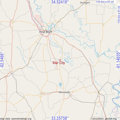
Star City GPS coordinates[2]
33° 56' 34.368" North, 91° 50' 36.492" West
| Map corner | latitude | longitude |
|---|---|---|
| Upper-left | 34.52418°, | -92.5466° |
| Center: | 33.94288°, | -91.84347° |
| Lower-right: | 33.35758°, | -91.14035° |
| Map W x H: | 129.7×129.7 km | = 80.6×80.6mi |
| max Lat: | 71.29058° ⇑80.6% North |
| Star City: | 33.94288° |
| min Lat: | ⇓19.4% South 19.06759° |
| min Long | Star City | max Long |
| -171.73463° | -91.84347° | -66.98998° |
| W 36.2%⇐ | ⇒63.8% E |
Elevation
Elevation of Star City is 88 m = 289 ft, and this is 206.8 m = 678 ft below average elevation for this country.
| Max E: |
3189 m = 10463 ft | 72.1% |
| Avg. | 294.8 m = 967 ft | |
| Star City | 88 m = 289 ft | |
Min E: |
-60 m = -197 ft | 27.9% |
See also: United States elevation on elevation.city.
Geographical zone
Star City is located in North temperate zone (between Tropic of Cancer and the Arctic Circle). Distance of this Northern Tropic circle is 1168.2 km =725.9 mi to South.| Distance of | km | miles | from Star City |
|---|---|---|---|
| North Pole | 6233 | 3873 | to North |
| Arctic Circle | 3627.1 | 2253.8 | to North |
| Tropic Cancer | 1168.2 | 725.9 | to South |
| Equator | 3774.1 | 2345.1 | to South |


Nearby cities:
15 places around Star City: (largest is in red/bold)
• Altheimer
41.9 km =26 mi,  359°
359°
• Dumas
33 km =20.5 mi,  100°
100°
• Fordyce
54.5 km =33.9 mi,  254°
254°
• Gillett
47.2 km =29.3 mi,  65°
65°
• Gould
26.5 km =16.5 mi,  79°
79°
• Humphrey
54.8 km =34.1 mi,  13°
13°
• McGehee
53.9 km =33.5 mi,  130°
130°
• Monticello
35.2 km =21.9 mi,  172°
172°
• Pea Ridge
46.8 km =29.1 mi,  93°
93°
• Pine Bluff
35 km =21.7 mi,  335°
335°
• Rison
32 km =19.9 mi,  273°
273°
• Sulphur Springs
36.9 km =22.9 mi,  315°
315°
• Warren
42 km =26.1 mi,  209°
209°
• White Hall
43.3 km =26.9 mi,  328°
328°
• Wilmar
35.8 km =22.2 mi,  193°
193°
Sources, notices
• [Note1] Compared only with cities in United States existing in our database
• [Src1] Map data: © OpenStreetMap contributors (CC-BY-SA)
• [Src2] Other city data from geonames.org with taken over terms of usage.
• [Src3] Geographical zone / Annual Mean Temperature by Robert A. Rohde @ Wikipedia
