Woodville geodata
Woodville (Florida) is a populated place; located in United States in America/New_York (GMT-4) time zone. With population of 2,978 people, there are 9670 cities with bigger population in this country. Compared to other cities in United States, 92.4% of cities are located further ↑North; 58.5% of cities are located further ←West and 87.4% of cities have higher elevation than Woodville. Note1


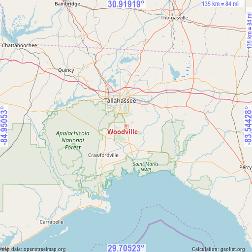
Woodville GPS coordinates[2]
30° 18' 50.724" North, 84° 14' 50.64" West
| Map corner | latitude | longitude |
|---|---|---|
| Upper-left | 30.91919°, | -84.95053° |
| Center: | 30.31409°, | -84.2474° |
| Lower-right: | 29.70523°, | -83.54428° |
| Map W x H: | 135×135 km | = 83.9×83.9mi |
| max Lat: | 71.29058° ⇑92.4% North |
| Woodville: | 30.31409° |
| min Lat: | ⇓7.6% South 19.06759° |
| min Long | Woodville | max Long |
| -171.73463° | -84.2474° | -66.98998° |
| W 58.5%⇐ | ⇒41.5% E |
Elevation
Elevation of Woodville is 22 m = 72 ft, and this is 272.8 m = 895 ft below average elevation for this country.
| Max E: |
3189 m = 10463 ft | 87.4% |
| Avg. | 294.8 m = 967 ft | |
| Woodville | 22 m = 72 ft | |
Min E: |
-60 m = -197 ft | 12.6% |
See also: United States elevation on elevation.city.
Geographical zone
Woodville is located in North temperate zone (between Tropic of Cancer and the Arctic Circle). Distance of this Northern Tropic circle is 764.7 km =475.2 mi to South.| Distance of | km | miles | from Woodville |
|---|---|---|---|
| North Pole | 6636.5 | 4123.7 | to North |
| Arctic Circle | 4030.6 | 2504.5 | to North |
| Tropic Cancer | 764.7 | 475.2 | to South |
| Equator | 3370.6 | 2094.4 | to South |


Nearby cities:
15 places around Woodville: (largest is in red/bold)
• Cairo
62.8 km =39 mi,  3°
3°
• Carrabelle
65.1 km =40.5 mi,  218°
218°
• Crawfordville
19.7 km =12.2 mi, 218°
• Greensboro
55.5 km =34.5 mi,  300°
300°
• Greenville
61.7 km =38.3 mi,  73°
73°
• Gretna
51.9 km =32.2 mi,  310°
310°
• Havana
38 km =23.6 mi,  335°
335°
• Hosford
53.6 km =33.3 mi,  278°
278°
• Midway
28.3 km =17.6 mi,  315°
315°
• Monticello
44.3 km =27.5 mi,  54°
54°
• Panacea
33.6 km =20.9 mi,  203°
203°
• Perry
67.5 km =41.9 mi,  108°
108°
• Quincy
44.3 km =27.5 mi, 313°
• Tallahassee
14.2 km =8.8 mi,  346°
346°
• Thomasville
63.5 km =39.5 mi,  23°
23°
Sources, notices
• [Note1] Compared only with cities in United States existing in our database
• [Src1] Map data: © OpenStreetMap contributors (CC-BY-SA)
• [Src2] Other city data from geonames.org with taken over terms of usage.
• [Src3] Geographical zone / Annual Mean Temperature by Robert A. Rohde @ Wikipedia
