Macclenny geodata
Macclenny (Florida) is a seat of a second-order administrative division; located in United States in America/New_York (GMT-4) time zone. With population of 6,487 people, there are 6118 cities with bigger population in this country. Compared to other cities in United States, 92.6% of cities are located further ↑North; 65.1% of cities are located further ←West and 80.6% of cities have higher elevation than Macclenny. Note1


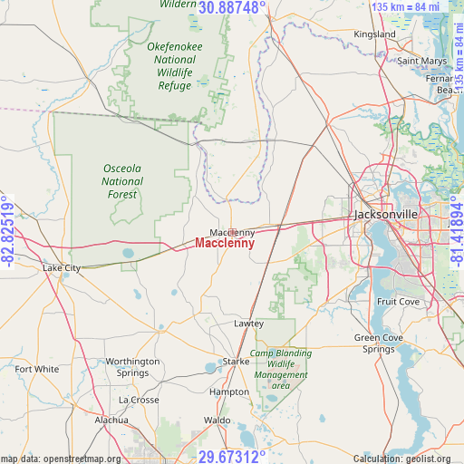
Macclenny GPS coordinates[2]
30° 16' 55.848" North, 82° 7' 19.416" West
| Map corner | latitude | longitude |
|---|---|---|
| Upper-left | 30.88748°, | -82.82519° |
| Center: | 30.28218°, | -82.12206° |
| Lower-right: | 29.67312°, | -81.41894° |
| Map W x H: | 135×135 km | = 83.9×83.9mi |
| max Lat: | 71.29058° ⇑92.6% North |
| Macclenny: | 30.28218° |
| min Lat: | ⇓7.4% South 19.06759° |
| min Long | Macclenny | max Long |
| -171.73463° | -82.12206° | -66.98998° |
| W 65.1%⇐ | ⇒34.9% E |
Elevation
Elevation of Macclenny is 44 m = 144 ft, and this is 250.8 m = 823 ft below average elevation for this country.
| Max E: |
3189 m = 10463 ft | 80.6% |
| Avg. | 294.8 m = 967 ft | |
| Macclenny | 44 m = 144 ft | |
Min E: |
-60 m = -197 ft | 19.4% |
See also: United States elevation on elevation.city.
Geographical zone
Macclenny is located in North temperate zone (between Tropic of Cancer and the Arctic Circle). Distance of this Northern Tropic circle is 761.1 km =472.9 mi to South.| Distance of | km | miles | from Macclenny |
|---|---|---|---|
| North Pole | 6640 | 4125.9 | to North |
| Arctic Circle | 4034.1 | 2506.7 | to North |
| Tropic Cancer | 761.1 | 472.9 | to South |
| Equator | 3367.1 | 2092.2 | to South |


Nearby cities:
15 places around Macclenny: (largest is in red/bold)
• Asbury Lake
38.8 km =24.1 mi,  131°
131°
• Baldwin
14.3 km =8.9 mi,  80°
80°
• Bellair-Meadowbrook Terrace
38.1 km =23.7 mi,  107°
107°
• Callahan
41.8 km =26 mi,  41°
41°
• Fleming Island
44.1 km =27.4 mi,  118°
118°
• Jacksonville
45.1 km =28 mi, 82°
• Lake Butler
35.6 km =22.1 mi,  215°
215°
• Lakeside
38 km =23.6 mi, 116°
• Lawtey
26.9 km =16.7 mi,  169°
169°
• Middleburg
34.6 km =21.5 mi, 133°
• Nassau Village-Ratliff
39.3 km =24.4 mi,  49°
49°
• Oakleaf Plantation
30.2 km =18.8 mi, 114°
• Orange Park
42 km =26.1 mi, 107°
• Penney Farms
45.1 km =28 mi,  138°
138°
• Starke
37.6 km =23.4 mi,  178°
178°
Sources, notices
• [Note1] Compared only with cities in United States existing in our database
• [Src1] Map data: © OpenStreetMap contributors (CC-BY-SA)
• [Src2] Other city data from geonames.org with taken over terms of usage.
• [Src3] Geographical zone / Annual Mean Temperature by Robert A. Rohde @ Wikipedia
