Pearson geodata
Pearson (Georgia) is a seat of a second-order administrative division; located in United States in America/New_York (GMT-4) time zone. With population of 2,112 people, there are 11578 cities with bigger population in this country. Compared to other cities in United States, 90.1% of cities are located further ↑North; 62.4% of cities are located further ←West and 76.2% of cities have higher elevation than Pearson. Note1


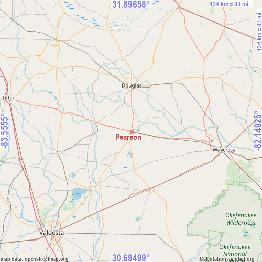
Pearson GPS coordinates[2]
31° 17' 51.72" North, 82° 51' 8.532" West
| Map corner | latitude | longitude |
|---|---|---|
| Upper-left | 31.89658°, | -83.5555° |
| Center: | 31.2977°, | -82.85237° |
| Lower-right: | 30.69499°, | -82.14925° |
| Map W x H: | 133.6×133.6 km | = 83×83mi |
| max Lat: | 71.29058° ⇑90.1% North |
| Pearson: | 31.2977° |
| min Lat: | ⇓9.9% South 19.06759° |
| min Long | Pearson | max Long |
| -171.73463° | -82.85237° | -66.98998° |
| W 62.4%⇐ | ⇒37.6% E |
Elevation
Elevation of Pearson is 65 m = 213 ft, and this is 229.8 m = 754 ft below average elevation for this country.
| Max E: |
3189 m = 10463 ft | 76.2% |
| Avg. | 294.8 m = 967 ft | |
| Pearson | 65 m = 213 ft | |
Min E: |
-60 m = -197 ft | 23.8% |
See also: United States elevation on elevation.city.
Geographical zone
Pearson is located in North temperate zone (between Tropic of Cancer and the Arctic Circle). Distance of this Northern Tropic circle is 874.1 km =543.1 mi to South.| Distance of | km | miles | from Pearson |
|---|---|---|---|
| North Pole | 6527.1 | 4055.8 | to North |
| Arctic Circle | 3921.2 | 2436.5 | to North |
| Tropic Cancer | 874.1 | 543.1 | to South |
| Equator | 3480 | 2162.4 | to South |


Nearby cities:
15 places around Pearson: (largest is in red/bold)
• Alapaha
36.5 km =22.7 mi,  285°
285°
• Alma
45.7 km =28.4 mi,  54°
54°
• Broxton
36.6 km =22.7 mi,  354°
354°
• Deenwood
45 km =28 mi,  100°
100°
• Douglas
23.5 km =14.6 mi,  0°
0°
• Enigma
47 km =29.2 mi, 285°
• Homerville
30.7 km =19.1 mi,  160°
160°
• Lakeland
35.5 km =22.1 mi,  216°
216°
• Nashville
39.1 km =24.3 mi,  255°
255°
• Nicholls
32 km =19.9 mi,  40°
40°
• Ray City
41.3 km =25.7 mi,  233°
233°
• Sunnyside
48.9 km =30.4 mi, 97°
• Talmo
27 km =16.8 mi,  86°
86°
• Waycross
48.1 km =29.9 mi, 101°
• Willacoochee
19 km =11.8 mi,  284°
284°
Sources, notices
• [Note1] Compared only with cities in United States existing in our database
• [Src1] Map data: © OpenStreetMap contributors (CC-BY-SA)
• [Src2] Other city data from geonames.org with taken over terms of usage.
• [Src3] Geographical zone / Annual Mean Temperature by Robert A. Rohde @ Wikipedia
