Macon geodata
Macon (Georgia) is a seat of a second-order administrative division; located in United States in America/New_York (GMT-4) time zone. With population of 91,351 people, there are 404 cities with bigger population in this country. Compared to other cities in United States, 85.8% of cities are located further ↑North; 60.3% of cities are located further ←West and 66.9% of cities have higher elevation than Macon. Note1


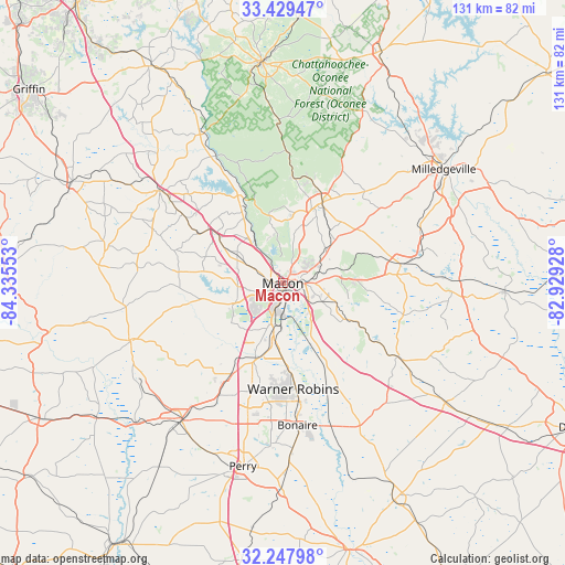
Macon GPS coordinates[2]
32° 50' 26.484" North, 83° 37' 56.64" West
| Map corner | latitude | longitude |
|---|---|---|
| Upper-left | 33.42947°, | -84.33553° |
| Center: | 32.84069°, | -83.6324° |
| Lower-right: | 32.24798°, | -82.92928° |
| Map W x H: | 131.4×131.4 km | = 81.6×81.6mi |
| max Lat: | 71.29058° ⇑85.8% North |
| Macon: | 32.84069° |
| min Lat: | ⇓14.2% South 19.06759° |
| min Long | Macon | max Long |
| -171.73463° | -83.6324° | -66.98998° |
| W 60.3%⇐ | ⇒39.7% E |
Elevation
Elevation of Macon is 118 m = 387 ft, and this is 176.8 m = 580 ft below average elevation for this country.
| Max E: |
3189 m = 10463 ft | 66.9% |
| Avg. | 294.8 m = 967 ft | |
| Macon | 118 m = 387 ft | |
Min E: |
-60 m = -197 ft | 33.1% |
See also: Macon elevation on elevation.city.
Geographical zone
Macon is located in North temperate zone (between Tropic of Cancer and the Arctic Circle). Distance of this Northern Tropic circle is 1045.6 km =649.7 mi to South.| Distance of | km | miles | from Macon |
|---|---|---|---|
| North Pole | 6355.5 | 3949.1 | to North |
| Arctic Circle | 3749.6 | 2329.9 | to North |
| Tropic Cancer | 1045.6 | 649.7 | to South |
| Equator | 3651.5 | 2268.9 | to South |


Nearby cities:
15 places around Macon: (largest is in red/bold)
• Byron
23.9 km =14.9 mi,  209°
209°
• Centerville
24 km =14.9 mi,  192°
192°
• Forsyth
35.7 km =22.2 mi,  307°
307°
• Fort Valley
39.8 km =24.7 mi,  216°
216°
• Gordon
28.4 km =17.6 mi,  80°
80°
• Gray
20.9 km =13 mi,  26°
26°
• Irwinton
43.1 km =26.8 mi,  94°
94°
• Ivey
32.8 km =20.4 mi, 76°
• Jeffersonville
31.7 km =19.7 mi,  122°
122°
• Knoxville
36.5 km =22.7 mi,  249°
249°
• McIntyre
41.3 km =25.7 mi, 89°
• Roberta
38 km =23.6 mi, 249°
• Robins Air Force Base
26.1 km =16.2 mi,  170°
170°
• Warner Robins
25 km =15.5 mi,  178°
178°
• West Point
17.2 km =10.7 mi, 252°
Sources, notices
• [Note1] Compared only with cities in United States existing in our database
• [Src1] Map data: © OpenStreetMap contributors (CC-BY-SA)
• [Src2] Other city data from geonames.org with taken over terms of usage.
• [Src3] Geographical zone / Annual Mean Temperature by Robert A. Rohde @ Wikipedia
