Dawson geodata
Dawson (Georgia) is a seat of a second-order administrative division; located in United States in America/New_York (GMT-4) time zone. With population of 4,353 people, there are 7804 cities with bigger population in this country. Compared to other cities in United States, 89.1% of cities are located further ↑North; 57.6% of cities are located further ←West and 68.5% of cities have higher elevation than Dawson. Note1


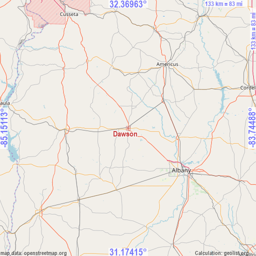
Dawson GPS coordinates[2]
31° 46' 25.752" North, 84° 26' 52.8" West
| Map corner | latitude | longitude |
|---|---|---|
| Upper-left | 32.36963°, | -85.15113° |
| Center: | 31.77382°, | -84.448° |
| Lower-right: | 31.17415°, | -83.74488° |
| Map W x H: | 132.9×132.9 km | = 82.6×82.6mi |
| max Lat: | 71.29058° ⇑89.1% North |
| Dawson: | 31.77382° |
| min Lat: | ⇓10.9% South 19.06759° |
| min Long | Dawson | max Long |
| -171.73463° | -84.448° | -66.98998° |
| W 57.6%⇐ | ⇒42.4% E |
Elevation
Elevation of Dawson is 110 m = 361 ft, and this is 184.8 m = 606 ft below average elevation for this country.
| Max E: |
3189 m = 10463 ft | 68.5% |
| Avg. | 294.8 m = 967 ft | |
| Dawson | 110 m = 361 ft | |
Min E: |
-60 m = -197 ft | 31.5% |
See also: United States elevation on elevation.city.
Geographical zone
Dawson is located in North temperate zone (between Tropic of Cancer and the Arctic Circle). Distance of this Northern Tropic circle is 927 km =576 mi to South.| Distance of | km | miles | from Dawson |
|---|---|---|---|
| North Pole | 6474.1 | 4022.8 | to North |
| Arctic Circle | 3868.3 | 2403.6 | to North |
| Tropic Cancer | 927 | 576 | to South |
| Equator | 3532.9 | 2195.2 | to South |


Nearby cities:
15 places around Dawson: (largest is in red/bold)
• Albany
35.2 km =21.9 mi,  128°
128°
• Americus
38.9 km =24.2 mi,  31°
31°
• Arlington
45.5 km =28.3 mi,  215°
215°
• Cuthbert
32.3 km =20.1 mi,  269°
269°
• Edison
36.5 km =22.7 mi,  228°
228°
• Leary
32.6 km =20.3 mi,  191°
191°
• Leesburg
26.6 km =16.5 mi,  100°
100°
• Lumpkin
45.3 km =28.1 mi,  312°
312°
• Morgan
29.9 km =18.6 mi,  208°
208°
• Plains
29.4 km =18.3 mi,  10°
10°
• Preston
33.6 km =20.9 mi,  345°
345°
• Putney
46 km =28.6 mi,  137°
137°
• Richland
40.6 km =25.2 mi,  329°
329°
• Shellman
15.9 km =9.9 mi,  262°
262°
• Smithville
23.3 km =14.5 mi,  52°
52°
Sources, notices
• [Note1] Compared only with cities in United States existing in our database
• [Src1] Map data: © OpenStreetMap contributors (CC-BY-SA)
• [Src2] Other city data from geonames.org with taken over terms of usage.
• [Src3] Geographical zone / Annual Mean Temperature by Robert A. Rohde @ Wikipedia
