Shellman geodata
Shellman (Georgia) is a populated place; located in United States in America/New_York (GMT-4) time zone. With population of 989 people, there are 16350 cities with bigger population in this country. Compared to other cities in United States, 89.1% of cities are located further ↑North; 56.9% of cities are located further ←West and 66.4% of cities have higher elevation than Shellman. Note1


Shellman GPS coordinates[2]
31° 45' 22.608" North, 84° 36' 54.72" West
| Map corner | latitude | longitude |
|---|---|---|
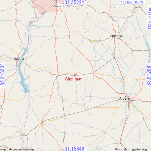
| Upper-left | 32.35221°, | -85.31833° |
| Center: | 31.75628°, | -84.6152° |
| Lower-right: | 31.15649°, | -83.91208° |
| Map W x H: | 133×133 km | = 82.6×82.6mi |
| max Lat: | 71.29058° ⇑89.1% North |
| Shellman: | 31.75628° |
| min Lat: | ⇓10.9% South 19.06759° |
| min Long | Shellman | max Long |
| -171.73463° | -84.6152° | -66.98998° |
| W 56.9%⇐ | ⇒43.1% E |
Elevation
Elevation of Shellman is 121 m = 397 ft, and this is 173.8 m = 570 ft below average elevation for this country.
| Max E: |
3189 m = 10463 ft | 66.4% |
| Avg. | 294.8 m = 967 ft | |
| Shellman | 121 m = 397 ft | |
Min E: |
-60 m = -197 ft | 33.6% |
See also: United States elevation on elevation.city.
Geographical zone
Shellman is located in North temperate zone (between Tropic of Cancer and the Arctic Circle). Distance of this Northern Tropic circle is 925 km =574.8 mi to South.| Distance of | km | miles | from Shellman |
|---|---|---|---|
| North Pole | 6476.1 | 4024.1 | to North |
| Arctic Circle | 3870.2 | 2404.8 | to North |
| Tropic Cancer | 925 | 574.8 | to South |
| Equator | 3531 | 2194.1 | to South |


Nearby cities:
15 places around Shellman: (largest is in red/bold)
• Albany
47.8 km =29.7 mi,  114°
114°
• Arlington
36.7 km =22.8 mi,  196°
196°
• Cuthbert
16.5 km =10.3 mi,  275°
275°
• Dawson
15.9 km =9.9 mi,  82°
82°
• Edison
24.9 km =15.5 mi,  207°
207°
• Fort Gaines
44.2 km =27.5 mi,  248°
248°
• Georgetown
48.6 km =30.2 mi,  287°
287°
• Leary
31.6 km =19.6 mi,  162°
162°
• Leesburg
42.1 km =26.2 mi,  93°
93°
• Lumpkin
37.1 km =23.1 mi,  332°
332°
• Morgan
24.4 km =15.2 mi,  176°
176°
• Plains
37.4 km =23.2 mi,  34°
34°
• Preston
35.2 km =21.9 mi,  12°
12°
• Richland
37.2 km =23.1 mi,  352°
352°
• Smithville
37.9 km =23.5 mi,  64°
64°
Sources, notices
• [Note1] Compared only with cities in United States existing in our database
• [Src1] Map data: © OpenStreetMap contributors (CC-BY-SA)
• [Src2] Other city data from geonames.org with taken over terms of usage.
• [Src3] Geographical zone / Annual Mean Temperature by Robert A. Rohde @ Wikipedia
