Columbus geodata
Columbus (Georgia) is a seat of a second-order administrative division; located in United States in America/New_York (GMT-4) time zone. With population of 200,579 people, there are 129 cities with bigger population in this country. Compared to other cities in United States, 87.3% of cities are located further ↑North; 55.9% of cities are located further ←West and 74.4% of cities have higher elevation than Columbus. Note1


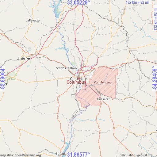
Columbus GPS coordinates[2]
32° 27' 39.528" North, 84° 59' 15.756" West
| Map corner | latitude | longitude |
|---|---|---|
| Upper-left | 33.05229°, | -85.69084° |
| Center: | 32.46098°, | -84.98771° |
| Lower-right: | 31.86577°, | -84.28459° |
| Map W x H: | 131.9×131.9 km | = 82×82mi |
| max Lat: | 71.29058° ⇑87.3% North |
| Columbus: | 32.46098° |
| min Lat: | ⇓12.7% South 19.06759° |
| min Long | Columbus | max Long |
| -171.73463° | -84.98771° | -66.98998° |
| W 55.9%⇐ | ⇒44.1% E |
Elevation
Elevation of Columbus is 75 m = 246 ft, and this is 219.8 m = 721 ft below average elevation for this country.
| Max E: |
3189 m = 10463 ft | 74.4% |
| Avg. | 294.8 m = 967 ft | |
| Columbus | 75 m = 246 ft | |
Min E: |
-60 m = -197 ft | 25.6% |
See also: Columbus elevation on elevation.city.
Geographical zone
Columbus is located in North temperate zone (between Tropic of Cancer and the Arctic Circle). Distance of this Northern Tropic circle is 1003.4 km =623.5 mi to South.| Distance of | km | miles | from Columbus |
|---|---|---|---|
| North Pole | 6397.7 | 3975.3 | to North |
| Arctic Circle | 3791.9 | 2356.2 | to North |
| Tropic Cancer | 1003.4 | 623.5 | to South |
| Equator | 3609.3 | 2242.7 | to South |


Nearby cities:
15 places around Columbus: (largest is in red/bold)
• Bibb City
3.9 km =2.4 mi,  354°
354°
• Buena Vista
46.9 km =29.1 mi,  109°
109°
• Cusseta
26.6 km =16.5 mi,  130°
130°
• Hamilton
34.7 km =21.6 mi,  17°
17°
• Huguley
47.3 km =29.4 mi,  331°
331°
• Hurtsboro
47.1 km =29.3 mi,  238°
238°
• Ladonia
8.6 km =5.3 mi,  275°
275°
• Lumpkin
48.9 km =30.4 mi,  158°
158°
• Opelika
42 km =26.1 mi,  299°
299°
• Phenix City
1.7 km =1.1 mi,  312°
312°
• Pine Mountain
46.6 km =29 mi, 15°
• Smiths Station
13.6 km =8.5 mi, 310°
• Talbotton
48.4 km =30.1 mi,  60°
60°
• Valley
43.6 km =27.1 mi,  335°
335°
• Waverly Hall
34 km =21.1 mi,  43°
43°
Sources, notices
• [Note1] Compared only with cities in United States existing in our database
• [Src1] Map data: © OpenStreetMap contributors (CC-BY-SA)
• [Src2] Other city data from geonames.org with taken over terms of usage.
• [Src3] Geographical zone / Annual Mean Temperature by Robert A. Rohde @ Wikipedia
