Tennille geodata
Tennille (Georgia) is a populated place; located in United States in America/New_York (GMT-4) time zone. With population of 1,773 people, there are 12655 cities with bigger population in this country. Compared to other cities in United States, 85.4% of cities are located further ↑North; 62.5% of cities are located further ←West and 61.7% of cities have higher elevation than Tennille. Note1


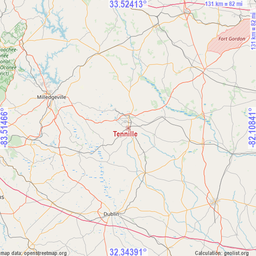
Tennille GPS coordinates[2]
32° 56' 9.564" North, 82° 48' 41.508" West
| Map corner | latitude | longitude |
|---|---|---|
| Upper-left | 33.52413°, | -83.51466° |
| Center: | 32.93599°, | -82.81153° |
| Lower-right: | 32.34391°, | -82.10841° |
| Map W x H: | 131.2×131.2 km | = 81.5×81.5mi |
| max Lat: | 71.29058° ⇑85.4% North |
| Tennille: | 32.93599° |
| min Lat: | ⇓14.6% South 19.06759° |
| min Long | Tennille | max Long |
| -171.73463° | -82.81153° | -66.98998° |
| W 62.5%⇐ | ⇒37.5% E |
Elevation
Elevation of Tennille is 146 m = 479 ft, and this is 148.8 m = 488 ft below average elevation for this country.
| Max E: |
3189 m = 10463 ft | 61.7% |
| Avg. | 294.8 m = 967 ft | |
| Tennille | 146 m = 479 ft | |
Min E: |
-60 m = -197 ft | 38.3% |
See also: United States elevation on elevation.city.
Geographical zone
Tennille is located in North temperate zone (between Tropic of Cancer and the Arctic Circle). Distance of this Northern Tropic circle is 1056.2 km =656.3 mi to South.| Distance of | km | miles | from Tennille |
|---|---|---|---|
| North Pole | 6344.9 | 3942.5 | to North |
| Arctic Circle | 3739 | 2323.3 | to North |
| Tropic Cancer | 1056.2 | 656.3 | to South |
| Equator | 3662.1 | 2275.5 | to South |


Nearby cities:
15 places around Tennille: (largest is in red/bold)
• Davisboro
19.6 km =12.2 mi,  75°
75°
• Dublin
44.8 km =27.8 mi,  191°
191°
• East Dublin
43.5 km =27 mi, 187°
• Gibson
38.7 km =24 mi,  31°
31°
• Hardwick
41.1 km =25.5 mi,  290°
290°
• Irwinton
36.5 km =22.7 mi,  247°
247°
• Ivey
44.8 km =27.8 mi,  265°
265°
• Louisville
38 km =23.6 mi, 78°
• McIntyre
36.8 km =22.9 mi, 254°
• Milledgeville
42.4 km =26.3 mi, 292°
• Sandersville
5.1 km =3.2 mi,  1°
1°
• Sparks
18.2 km =11.3 mi,  22°
22°
• Sparta
40.8 km =25.4 mi,  337°
337°
• Wadley
38.8 km =24.1 mi,  101°
101°
• Wrightsville
24.5 km =15.2 mi,  159°
159°
Sources, notices
• [Note1] Compared only with cities in United States existing in our database
• [Src1] Map data: © OpenStreetMap contributors (CC-BY-SA)
• [Src2] Other city data from geonames.org with taken over terms of usage.
• [Src3] Geographical zone / Annual Mean Temperature by Robert A. Rohde @ Wikipedia
