McIntyre geodata
McIntyre (Georgia) is a populated place; located in United States in America/New_York (GMT-4) time zone. With population of 620 people, there are 19469 cities with bigger population in this country. Compared to other cities in United States, 85.7% of cities are located further ↑North; 61.4% of cities are located further ←West and 72.7% of cities have higher elevation than McIntyre. Note1


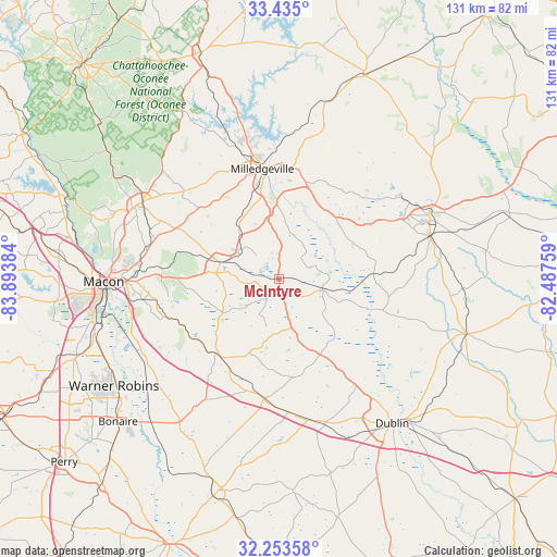
McIntyre GPS coordinates[2]
32° 50' 46.536" North, 83° 11' 26.556" West
| Map corner | latitude | longitude |
|---|---|---|
| Upper-left | 33.435°, | -83.89384° |
| Center: | 32.84626°, | -83.19071° |
| Lower-right: | 32.25358°, | -82.48759° |
| Map W x H: | 131.4×131.4 km | = 81.6×81.6mi |
| max Lat: | 71.29058° ⇑85.7% North |
| McIntyre: | 32.84626° |
| min Lat: | ⇓14.3% South 19.06759° |
| min Long | McIntyre | max Long |
| -171.73463° | -83.19071° | -66.98998° |
| W 61.4%⇐ | ⇒38.6% E |
Elevation
Elevation of McIntyre is 85 m = 279 ft, and this is 209.8 m = 688 ft below average elevation for this country.
| Max E: |
3189 m = 10463 ft | 72.7% |
| Avg. | 294.8 m = 967 ft | |
| McIntyre | 85 m = 279 ft | |
Min E: |
-60 m = -197 ft | 27.3% |
See also: United States elevation on elevation.city.
Geographical zone
McIntyre is located in North temperate zone (between Tropic of Cancer and the Arctic Circle). Distance of this Northern Tropic circle is 1046.2 km =650.1 mi to South.| Distance of | km | miles | from McIntyre |
|---|---|---|---|
| North Pole | 6354.9 | 3948.8 | to North |
| Arctic Circle | 3749 | 2329.5 | to North |
| Tropic Cancer | 1046.2 | 650.1 | to South |
| Equator | 3652.2 | 2269.4 | to South |


Nearby cities:
15 places around McIntyre: (largest is in red/bold)
• Dublin
43.3 km =26.9 mi,  141°
141°
• Dudley
35.6 km =22.1 mi,  161°
161°
• East Dublin
44.6 km =27.7 mi, 137°
• Gordon
13.8 km =8.6 mi,  286°
286°
• Gray
36.8 km =22.9 mi,  299°
299°
• Hardwick
24.9 km =15.5 mi,  352°
352°
• Irwinton
4.2 km =2.6 mi, 156°
• Ivey
11.5 km =7.1 mi,  305°
305°
• Jeffersonville
22.9 km =14.2 mi,  219°
219°
• Macon
41.3 km =25.7 mi,  269°
269°
• Milledgeville
26.3 km =16.3 mi, 351°
• Robins Air Force Base
45.3 km =28.1 mi,  234°
234°
• Sandersville
38.6 km =24 mi,  67°
67°
• Tennille
36.8 km =22.9 mi, 74°
• Wrightsville
45.9 km =28.5 mi,  106°
106°
Sources, notices
• [Note1] Compared only with cities in United States existing in our database
• [Src1] Map data: © OpenStreetMap contributors (CC-BY-SA)
• [Src2] Other city data from geonames.org with taken over terms of usage.
• [Src3] Geographical zone / Annual Mean Temperature by Robert A. Rohde @ Wikipedia
