Thomasville geodata
Thomasville (Georgia) is a seat of a second-order administrative division; located in United States in America/New_York (GMT-4) time zone. With population of 18,742 people, there are 2688 cities with bigger population in this country. Compared to other cities in United States, 91% of cities are located further ↑North; 59.3% of cities are located further ←West and 72.1% of cities have higher elevation than Thomasville. Note1


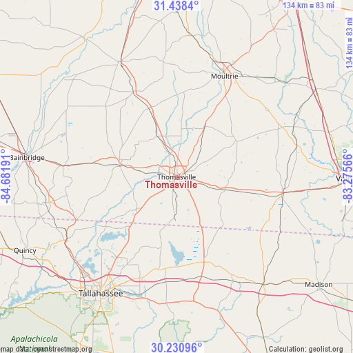
Thomasville GPS coordinates[2]
30° 50' 11.688" North, 83° 58' 43.608" West
| Map corner | latitude | longitude |
|---|---|---|
| Upper-left | 31.4384°, | -84.68191° |
| Center: | 30.83658°, | -83.97878° |
| Lower-right: | 30.23096°, | -83.27566° |
| Map W x H: | 134.3×134.3 km | = 83.5×83.5mi |
| max Lat: | 71.29058° ⇑91% North |
| Thomasville: | 30.83658° |
| min Lat: | ⇓9% South 19.06759° |
| min Long | Thomasville | max Long |
| -171.73463° | -83.97878° | -66.98998° |
| W 59.3%⇐ | ⇒40.7% E |
Elevation
Elevation of Thomasville is 88 m = 289 ft, and this is 206.8 m = 678 ft below average elevation for this country.
| Max E: |
3189 m = 10463 ft | 72.1% |
| Avg. | 294.8 m = 967 ft | |
| Thomasville | 88 m = 289 ft | |
Min E: |
-60 m = -197 ft | 27.9% |
See also: United States elevation on elevation.city.
Geographical zone
Thomasville is located in North temperate zone (between Tropic of Cancer and the Arctic Circle). Distance of this Northern Tropic circle is 822.8 km =511.3 mi to South.| Distance of | km | miles | from Thomasville |
|---|---|---|---|
| North Pole | 6578.4 | 4087.6 | to North |
| Arctic Circle | 3972.5 | 2468.4 | to North |
| Tropic Cancer | 822.8 | 511.3 | to South |
| Equator | 3428.7 | 2130.5 | to South |


Nearby cities:
15 places around Thomasville: (largest is in red/bold)
• Berlin
42.5 km =26.4 mi,  52°
52°
• Boston
18.7 km =11.6 mi,  105°
105°
• Cairo
21.8 km =13.5 mi,  282°
282°
• Camilla
49.1 km =30.5 mi,  333°
333°
• Coolidge
22.2 km =13.8 mi,  28°
28°
• Greenville
52.7 km =32.7 mi,  140°
140°
• Havana
47.9 km =29.8 mi,  240°
240°
• Meigs
28.3 km =17.6 mi,  338°
338°
• Monticello
34 km =21.1 mi,  162°
162°
• Morven
47.2 km =29.3 mi,  75°
75°
• Moultrie
42.2 km =26.2 mi, 25°
• Ochlocknee
16.9 km =10.5 mi, 334°
• Pavo
26.8 km =16.7 mi,  59°
59°
• Pelham
36.4 km =22.6 mi, 332°
• Quitman
40.4 km =25.1 mi,  98°
98°
Sources, notices
• [Note1] Compared only with cities in United States existing in our database
• [Src1] Map data: © OpenStreetMap contributors (CC-BY-SA)
• [Src2] Other city data from geonames.org with taken over terms of usage.
• [Src3] Geographical zone / Annual Mean Temperature by Robert A. Rohde @ Wikipedia
