Camilla geodata
Camilla (Georgia) is a seat of a second-order administrative division; located in United States in America/New_York (GMT-4) time zone. With population of 5,089 people, there are 7090 cities with bigger population in this country. Compared to other cities in United States, 90.2% of cities are located further ↑North; 58.6% of cities are located further ←West and 77.5% of cities have higher elevation than Camilla. Note1


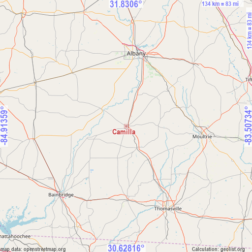
Camilla GPS coordinates[2]
31° 13' 52.644" North, 84° 12' 37.656" West
| Map corner | latitude | longitude |
|---|---|---|
| Upper-left | 31.8306°, | -84.91359° |
| Center: | 31.23129°, | -84.21046° |
| Lower-right: | 30.62816°, | -83.50734° |
| Map W x H: | 133.7×133.7 km | = 83.1×83.1mi |
| max Lat: | 71.29058° ⇑90.2% North |
| Camilla: | 31.23129° |
| min Lat: | ⇓9.8% South 19.06759° |
| min Long | Camilla | max Long |
| -171.73463° | -84.21046° | -66.98998° |
| W 58.6%⇐ | ⇒41.4% E |
Elevation
Elevation of Camilla is 58 m = 190 ft, and this is 236.8 m = 777 ft below average elevation for this country.
| Max E: |
3189 m = 10463 ft | 77.5% |
| Avg. | 294.8 m = 967 ft | |
| Camilla | 58 m = 190 ft | |
Min E: |
-60 m = -197 ft | 22.5% |
See also: United States elevation on elevation.city.
Geographical zone
Camilla is located in North temperate zone (between Tropic of Cancer and the Arctic Circle). Distance of this Northern Tropic circle is 866.7 km =538.5 mi to South.| Distance of | km | miles | from Camilla |
|---|---|---|---|
| North Pole | 6534.5 | 4060.3 | to North |
| Arctic Circle | 3928.6 | 2441.1 | to North |
| Tropic Cancer | 866.7 | 538.5 | to South |
| Equator | 3472.6 | 2157.8 | to South |


Nearby cities:
15 places around Camilla: (largest is in red/bold)
• Albany
39 km =24.2 mi,  7°
7°
• Baconton
17.1 km =10.6 mi,  15°
15°
• Cairo
39.3 km =24.4 mi,  178°
178°
• Coolidge
40.9 km =25.4 mi,  126°
126°
• Doerun
29.6 km =18.4 mi,  70°
70°
• Leary
40.4 km =25.1 mi,  314°
314°
• Meigs
21.1 km =13.1 mi,  146°
146°
• Moultrie
40.5 km =25.2 mi,  98°
98°
• Newton
15 km =9.3 mi, 307°
• Norman Park
49.9 km =31 mi,  85°
85°
• Ochlocknee
32.2 km =20 mi, 152°
• Pelham
12.7 km =7.9 mi, 154°
• Putney
28 km =17.4 mi, 18°
• Sylvester
48.7 km =30.3 mi,  46°
46°
• Thomasville
49.1 km =30.5 mi, 153°
Sources, notices
• [Note1] Compared only with cities in United States existing in our database
• [Src1] Map data: © OpenStreetMap contributors (CC-BY-SA)
• [Src2] Other city data from geonames.org with taken over terms of usage.
• [Src3] Geographical zone / Annual Mean Temperature by Robert A. Rohde @ Wikipedia
