Wakefield geodata
Wakefield (Kansas) is a populated place; located in United States in America/Chicago (GMT-5) time zone. With population of 980 people, there are 16412 cities with bigger population in this country. Compared to other cities in United States, 53% of cities are located further ↑North; 75.7% of cities are located further →East and 79.3% of cities have lower elevation than Wakefield. Note1


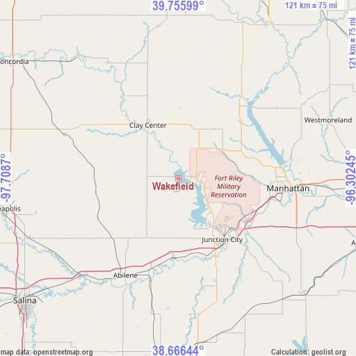
Wakefield GPS coordinates[2]
39° 12' 47.988" North, 97° 0' 20.052" West
| Map corner | latitude | longitude |
|---|---|---|
| Upper-left | 39.75599°, | -97.7087° |
| Center: | 39.21333°, | -97.00557° |
| Lower-right: | 38.66644°, | -96.30245° |
| Map W x H: | 121.1×121.1 km | = 75.2×75.2mi |
| max Lat: | 71.29058° ⇑53% North |
| Wakefield: | 39.21333° |
| min Lat: | ⇓47% South 19.06759° |
| min Long | Wakefield | max Long |
| -171.73463° | -97.00557° | -66.98998° |
| W 24.3%⇐ | ⇒75.7% E |
Elevation
Elevation of Wakefield is 347 m = 1138 ft, and this is 52.2 m = 171 ft above average elevation for this country.
| Max E: |
3189 m = 10463 ft | 20.7% |
| Wakefield | 347 m 1138 ft | |
| Avg. | 294.8 m = 967 ft | |
Min E: |
-60 m = -197 ft | 79.3% |
See also: United States elevation on elevation.city.
Geographical zone
Wakefield is located in North temperate zone (between Tropic of Cancer and the Arctic Circle). Distance of this Northern Tropic circle is 1754.2 km =1090 mi to South.| Distance of | km | miles | from Wakefield |
|---|---|---|---|
| North Pole | 5646.9 | 3508.8 | to North |
| Arctic Circle | 3041.1 | 1889.7 | to North |
| Tropic Cancer | 1754.2 | 1090 | to South |
| Equator | 4360.1 | 2709.2 | to South |


Nearby cities:
15 places around Wakefield: (largest is in red/bold)
• Abilene
37.5 km =23.3 mi,  208°
208°
• Chapman
26.8 km =16.7 mi,  183°
183°
• Clay Center
20.9 km =13 mi,  330°
330°
• Clifton
45.8 km =28.5 mi, 329°
• Enterprise
35.8 km =22.2 mi,  195°
195°
• Fort Riley North
20.1 km =12.5 mi,  124°
124°
• Grandview Plaza
27.7 km =17.2 mi,  137°
137°
• Junction City
25.4 km =15.8 mi, 143°
• Manhattan
37.5 km =23.3 mi,  95°
95°
• Milford
9.5 km =5.9 mi, 121°
• Miltonvale
40.8 km =25.4 mi,  291°
291°
• Ogden
28.2 km =17.5 mi,  113°
113°
• Riley
17.8 km =11.1 mi,  57°
57°
• Saint George
50.5 km =31.4 mi,  92°
92°
• Solomon
45.4 km =28.2 mi,  224°
224°
Sources, notices
• [Note1] Compared only with cities in United States existing in our database
• [Src1] Map data: © OpenStreetMap contributors (CC-BY-SA)
• [Src2] Other city data from geonames.org with taken over terms of usage.
• [Src3] Geographical zone / Annual Mean Temperature by Robert A. Rohde @ Wikipedia
