Clay Center geodata
Clay Center (Kansas) is a seat of a second-order administrative division; located in United States in America/Chicago (GMT-5) time zone. With population of 4,173 people, there are 8024 cities with bigger population in this country. Compared to other cities in United States, 51.7% of cities are located further ↑North; 76.1% of cities are located further →East and 81.3% of cities have lower elevation than Clay Center. Note1


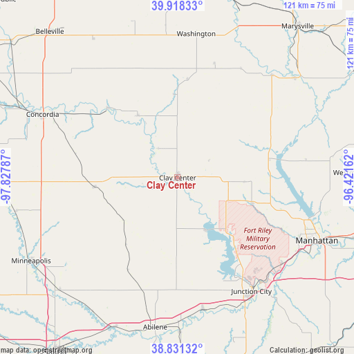
Clay Center GPS coordinates[2]
39° 22' 36.984" North, 97° 7' 29.064" West
| Map corner | latitude | longitude |
|---|---|---|
| Upper-left | 39.91833°, | -97.82787° |
| Center: | 39.37694°, | -97.12474° |
| Lower-right: | 38.83132°, | -96.42162° |
| Map W x H: | 120.9×120.9 km | = 75.1×75.1mi |
| max Lat: | 71.29058° ⇑51.7% North |
| Clay Center: | 39.37694° |
| min Lat: | ⇓48.3% South 19.06759° |
| min Long | Clay Center | max Long |
| -171.73463° | -97.12474° | -66.98998° |
| W 23.9%⇐ | ⇒76.1% E |
Elevation
Elevation of Clay Center is 368 m = 1207 ft, and this is 73.2 m = 240 ft above average elevation for this country.
| Max E: |
3189 m = 10463 ft | 18.7% |
| Clay Center | 368 m 1207 ft | |
| Avg. | 294.8 m = 967 ft | |
Min E: |
-60 m = -197 ft | 81.3% |
See also: United States elevation on elevation.city.
Geographical zone
Clay Center is located in North temperate zone (between Tropic of Cancer and the Arctic Circle). Distance of this Northern Tropic circle is 1772.4 km =1101.3 mi to South.| Distance of | km | miles | from Clay Center |
|---|---|---|---|
| North Pole | 5628.8 | 3497.6 | to North |
| Arctic Circle | 3022.9 | 1878.3 | to North |
| Tropic Cancer | 1772.4 | 1101.3 | to South |
| Equator | 4378.3 | 2720.5 | to South |


Nearby cities:
15 places around Clay Center: (largest is in red/bold)
• Abilene
51.7 km =32.1 mi,  188°
188°
• Chapman
45.9 km =28.5 mi,  168°
168°
• Clifton
24.9 km =15.5 mi,  328°
328°
• Clyde
33.5 km =20.8 mi,  315°
315°
• Concordia
50.9 km =31.6 mi,  295°
295°
• Fort Riley North
39.9 km =24.8 mi,  137°
137°
• Grandview Plaza
48.3 km =30 mi, 143°
• Junction City
46.2 km =28.7 mi,  146°
146°
• Milford
29.5 km =18.3 mi, 141°
• Miltonvale
27.8 km =17.3 mi,  263°
263°
• Ogden
46.6 km =29 mi,  129°
129°
• Riley
26.7 km =16.6 mi,  108°
108°
• Wakefield
20.9 km =13 mi, 150°
• Washington
49.5 km =30.8 mi,  7°
7°
• Waterville
47.6 km =29.6 mi,  42°
42°
Sources, notices
• [Note1] Compared only with cities in United States existing in our database
• [Src1] Map data: © OpenStreetMap contributors (CC-BY-SA)
• [Src2] Other city data from geonames.org with taken over terms of usage.
• [Src3] Geographical zone / Annual Mean Temperature by Robert A. Rohde @ Wikipedia
