Washington geodata
Washington (Kansas) is a seat of a second-order administrative division; located in United States in America/Chicago (GMT-5) time zone. With population of 1,085 people, there are 15756 cities with bigger population in this country. Compared to other cities in United States, 51.7% of cities are located further ↓South; 75.9% of cities are located further →East and 84.1% of cities have lower elevation than Washington. Note1


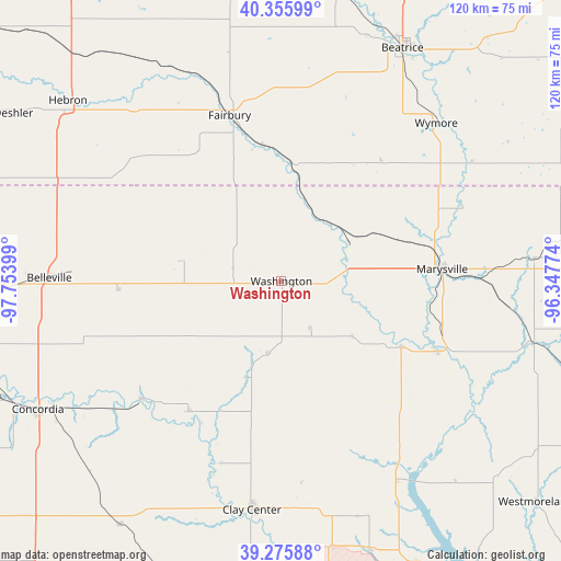
Washington GPS coordinates[2]
39° 49' 5.016" North, 97° 3' 3.096" West
| Map corner | latitude | longitude |
|---|---|---|
| Upper-left | 40.35599°, | -97.75399° |
| Center: | 39.81806°, | -97.05086° |
| Lower-right: | 39.27588°, | -96.34774° |
| Map W x H: | 120.1×120.1 km | = 74.6×74.6mi |
| max Lat: | 71.29058° ⇑48.3% North |
| Washington: | 39.81806° |
| min Lat: | ⇓51.7% South 19.06759° |
| min Long | Washington | max Long |
| -171.73463° | -97.05086° | -66.98998° |
| W 24.1%⇐ | ⇒75.9% E |
Elevation
Elevation of Washington is 407 m = 1335 ft, and this is 112.2 m = 368 ft above average elevation for this country.
| Max E: |
3189 m = 10463 ft | 15.9% |
| Washington | 407 m 1335 ft | |
| Avg. | 294.8 m = 967 ft | |
Min E: |
-60 m = -197 ft | 84.1% |
See also: United States elevation on elevation.city.
Geographical zone
Washington is located in North temperate zone (between Tropic of Cancer and the Arctic Circle). Distance of this Northern Tropic circle is 1821.4 km =1131.8 mi to South.| Distance of | km | miles | from Washington |
|---|---|---|---|
| North Pole | 5579.7 | 3467.1 | to North |
| Arctic Circle | 2973.8 | 1847.8 | to North |
| Tropic Cancer | 1821.4 | 1131.8 | to South |
| Equator | 4427.4 | 2751.1 | to South |


Nearby cities:
15 places around Washington: (largest is in red/bold)
• Beatrice
56.3 km =35 mi,  27°
27°
• Belleville
49.7 km =30.9 mi,  270°
270°
• Blue Rapids
36.7 km =22.8 mi,  114°
114°
• Clay Center
49.5 km =30.8 mi,  187°
187°
• Clifton
34 km =21.1 mi,  214°
214°
• Clyde
39 km =24.2 mi,  229°
229°
• Concordia
59.1 km =36.7 mi,  242°
242°
• Fairbury
37.2 km =23.1 mi,  342°
342°
• Frankfort
55.6 km =34.5 mi,  103°
103°
• Hanover
16.9 km =10.5 mi,  60°
60°
• Hebron
59.8 km =37.2 mi,  310°
310°
• Marysville
34.6 km =21.5 mi,  85°
85°
• Riley
60.7 km =37.7 mi,  161°
161°
• Waterville
29.5 km =18.3 mi,  118°
118°
• Wymore
47.3 km =29.4 mi,  44°
44°
Sources, notices
• [Note1] Compared only with cities in United States existing in our database
• [Src1] Map data: © OpenStreetMap contributors (CC-BY-SA)
• [Src2] Other city data from geonames.org with taken over terms of usage.
• [Src3] Geographical zone / Annual Mean Temperature by Robert A. Rohde @ Wikipedia
