Emporia geodata
Emporia (Kansas) is a seat of a second-order administrative division; located in United States in America/Chicago (GMT-5) time zone. With population of 24,649 people, there are 2046 cities with bigger population in this country. Compared to other cities in United States, 59.4% of cities are located further ↑North; 73.8% of cities are located further →East and 80% of cities have lower elevation than Emporia. Note1


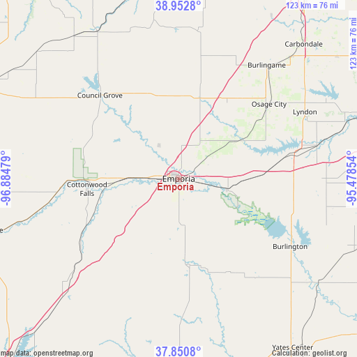
Emporia GPS coordinates[2]
38° 24' 14.04" North, 96° 10' 53.976" West
| Map corner | latitude | longitude |
|---|---|---|
| Upper-left | 38.9528°, | -96.88479° |
| Center: | 38.4039°, | -96.18166° |
| Lower-right: | 37.8508°, | -95.47854° |
| Map W x H: | 122.5×122.5 km | = 76.1×76.1mi |
| max Lat: | 71.29058° ⇑59.4% North |
| Emporia: | 38.4039° |
| min Lat: | ⇓40.6% South 19.06759° |
| min Long | Emporia | max Long |
| -171.73463° | -96.18166° | -66.98998° |
| W 26.2%⇐ | ⇒73.8% E |
Elevation
Elevation of Emporia is 353 m = 1158 ft, and this is 58.2 m = 191 ft above average elevation for this country.
| Max E: |
3189 m = 10463 ft | 20% |
| Emporia | 353 m 1158 ft | |
| Avg. | 294.8 m = 967 ft | |
Min E: |
-60 m = -197 ft | 80% |
See also: United States elevation on elevation.city.
Geographical zone
Emporia is located in North temperate zone (between Tropic of Cancer and the Arctic Circle). Distance of this Northern Tropic circle is 1664.2 km =1034.1 mi to South.| Distance of | km | miles | from Emporia |
|---|---|---|---|
| North Pole | 5736.9 | 3564.7 | to North |
| Arctic Circle | 3131.1 | 1945.6 | to North |
| Tropic Cancer | 1664.2 | 1034.1 | to South |
| Equator | 4270.1 | 2653.3 | to South |


Nearby cities:
15 places around Emporia: (largest is in red/bold)
• Americus
13.4 km =8.3 mi,  328°
328°
• Burlingame
49.2 km =30.6 mi,  37°
37°
• Burlington
44.8 km =27.8 mi,  121°
121°
• Cottonwood Falls
31.7 km =19.7 mi,  263°
263°
• Council Grove
39.3 km =24.4 mi,  316°
316°
• Eskridge
51 km =31.7 mi,  7°
7°
• LeRoy
59.6 km =37 mi,  126°
126°
• Lebo
28.7 km =17.8 mi,  87°
87°
• Lyndon
49 km =30.4 mi,  62°
62°
• Madison
30.1 km =18.7 mi,  172°
172°
• Olpe
15.8 km =9.8 mi,  175°
175°
• Osage City
40.2 km =25 mi,  50°
50°
• Scranton
57 km =35.4 mi, 42°
• Vassar
55.7 km =34.6 mi, 60°
• Waverly
50.4 km =31.3 mi, 91°
Sources, notices
• [Note1] Compared only with cities in United States existing in our database
• [Src1] Map data: © OpenStreetMap contributors (CC-BY-SA)
• [Src2] Other city data from geonames.org with taken over terms of usage.
• [Src3] Geographical zone / Annual Mean Temperature by Robert A. Rohde @ Wikipedia
