Lebo geodata
Lebo (Kansas) is a populated place; located in United States in America/Chicago (GMT-5) time zone. With population of 905 people, there are 16946 cities with bigger population in this country. Compared to other cities in United States, 59.2% of cities are located further ↑North; 73.1% of cities are located further →East and 80.7% of cities have lower elevation than Lebo. Note1


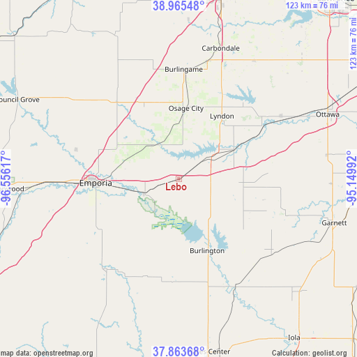
Lebo GPS coordinates[2]
38° 25' 0.048" North, 95° 51' 10.944" West
| Map corner | latitude | longitude |
|---|---|---|
| Upper-left | 38.96548°, | -96.55617° |
| Center: | 38.41668°, | -95.85304° |
| Lower-right: | 37.86368°, | -95.14992° |
| Map W x H: | 122.5×122.5 km | = 76.1×76.1mi |
| max Lat: | 71.29058° ⇑59.2% North |
| Lebo: | 38.41668° |
| min Lat: | ⇓40.8% South 19.06759° |
| min Long | Lebo | max Long |
| -171.73463° | -95.85304° | -66.98998° |
| W 26.9%⇐ | ⇒73.1% E |
Elevation
Elevation of Lebo is 361 m = 1184 ft, and this is 66.2 m = 217 ft above average elevation for this country.
| Max E: |
3189 m = 10463 ft | 19.3% |
| Lebo | 361 m 1184 ft | |
| Avg. | 294.8 m = 967 ft | |
Min E: |
-60 m = -197 ft | 80.7% |
See also: United States elevation on elevation.city.
Geographical zone
Lebo is located in North temperate zone (between Tropic of Cancer and the Arctic Circle). Distance of this Northern Tropic circle is 1665.6 km =1035 mi to South.| Distance of | km | miles | from Lebo |
|---|---|---|---|
| North Pole | 5735.5 | 3563.9 | to North |
| Arctic Circle | 3129.6 | 1944.6 | to North |
| Tropic Cancer | 1665.6 | 1035 | to South |
| Equator | 4271.5 | 2654.2 | to South |


Nearby cities:
15 places around Lebo: (largest is in red/bold)
• Americus
37 km =23 mi,  285°
285°
• Burlingame
37.5 km =23.3 mi,  2°
2°
• Burlington
26.5 km =16.5 mi,  158°
158°
• Carbondale
46.9 km =29.1 mi,  17°
17°
• Emporia
28.7 km =17.8 mi,  267°
267°
• LeRoy
41.6 km =25.8 mi,  152°
152°
• Lyndon
26 km =16.2 mi,  34°
34°
• Madison
39.8 km =24.7 mi,  218°
218°
• Olpe
32.3 km =20.1 mi,  237°
237°
• Osage City
24.3 km =15.1 mi,  5°
5°
• Pomona
40.1 km =24.9 mi,  60°
60°
• Pomona
40.9 km =25.4 mi, 58°
• Scranton
41.8 km =26 mi, 13°
• Vassar
32.5 km =20.2 mi,  38°
38°
• Waverly
21.9 km =13.6 mi,  96°
96°
Sources, notices
• [Note1] Compared only with cities in United States existing in our database
• [Src1] Map data: © OpenStreetMap contributors (CC-BY-SA)
• [Src2] Other city data from geonames.org with taken over terms of usage.
• [Src3] Geographical zone / Annual Mean Temperature by Robert A. Rohde @ Wikipedia
