Hanover geodata
Hanover (Kansas) is a populated place; located in United States in America/Chicago (GMT-5) time zone. With population of 668 people, there are 18991 cities with bigger population in this country. Compared to other cities in United States, 52.4% of cities are located further ↓South; 75.4% of cities are located further →East and 82.2% of cities have lower elevation than Hanover. Note1


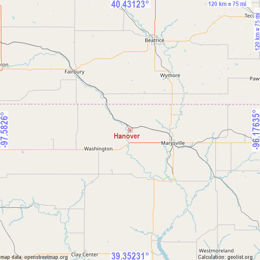
Hanover GPS coordinates[2]
39° 53' 38.004" North, 96° 52' 46.092" West
| Map corner | latitude | longitude |
|---|---|---|
| Upper-left | 40.43123°, | -97.5826° |
| Center: | 39.89389°, | -96.87947° |
| Lower-right: | 39.35231°, | -96.17635° |
| Map W x H: | 120×120 km | = 74.6×74.6mi |
| max Lat: | 71.29058° ⇑47.6% North |
| Hanover: | 39.89389° |
| min Lat: | ⇓52.4% South 19.06759° |
| min Long | Hanover | max Long |
| -171.73463° | -96.87947° | -66.98998° |
| W 24.6%⇐ | ⇒75.4% E |
Elevation
Elevation of Hanover is 378 m = 1240 ft, and this is 83.2 m = 273 ft above average elevation for this country.
| Max E: |
3189 m = 10463 ft | 17.8% |
| Hanover | 378 m 1240 ft | |
| Avg. | 294.8 m = 967 ft | |
Min E: |
-60 m = -197 ft | 82.2% |
See also: United States elevation on elevation.city.
Geographical zone
Hanover is located in North temperate zone (between Tropic of Cancer and the Arctic Circle). Distance of this Northern Tropic circle is 1829.9 km =1137 mi to South.| Distance of | km | miles | from Hanover |
|---|---|---|---|
| North Pole | 5571.3 | 3461.8 | to North |
| Arctic Circle | 2965.4 | 1842.6 | to North |
| Tropic Cancer | 1829.9 | 1137 | to South |
| Equator | 4435.8 | 2756.3 | to South |


Nearby cities:
15 places around Hanover: (largest is in red/bold)
• Beatrice
43.1 km =26.8 mi,  15°
15°
• Belleville
64.7 km =40.2 mi,  263°
263°
• Blue Rapids
30.1 km =18.7 mi,  141°
141°
• Clay Center
61.2 km =38 mi,  200°
200°
• Clifton
49.8 km =30.9 mi,  223°
223°
• Clyde
55.7 km =34.6 mi,  232°
232°
• De Witt
55.7 km =34.6 mi,  356°
356°
• Fairbury
37.3 km =23.2 mi,  316°
316°
• Frankfort
44.7 km =27.8 mi,  117°
117°
• Marysville
20.7 km =12.9 mi,  106°
106°
• Pawnee City
66.2 km =41.1 mi,  68°
68°
• Washington
16.9 km =10.5 mi,  240°
240°
• Waterville
25.2 km =15.7 mi,  153°
153°
• Wilber
65.7 km =40.8 mi,  353°
353°
• Wymore
31.4 km =19.5 mi,  36°
36°
Sources, notices
• [Note1] Compared only with cities in United States existing in our database
• [Src1] Map data: © OpenStreetMap contributors (CC-BY-SA)
• [Src2] Other city data from geonames.org with taken over terms of usage.
• [Src3] Geographical zone / Annual Mean Temperature by Robert A. Rohde @ Wikipedia
