Winfield geodata
Winfield (Kansas) is a seat of a second-order administrative division; located in United States in America/Chicago (GMT-5) time zone. With population of 12,204 people, there are 3841 cities with bigger population in this country. Compared to other cities in United States, 65.1% of cities are located further ↑North; 75.7% of cities are located further →East and 79.5% of cities have lower elevation than Winfield. Note1


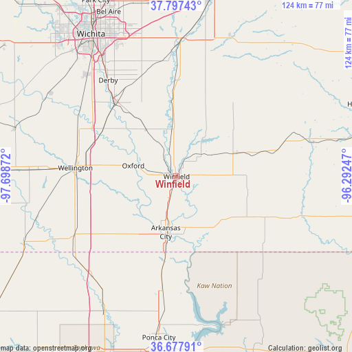
Winfield GPS coordinates[2]
37° 14' 23.1" North, 96° 59' 44.124" West
| Map corner | latitude | longitude |
|---|---|---|
| Upper-left | 37.79743°, | -97.69872° |
| Center: | 37.23975°, | -96.99559° |
| Lower-right: | 36.67791°, | -96.29247° |
| Map W x H: | 124.5×124.5 km | = 77.4×77.4mi |
| max Lat: | 71.29058° ⇑65.1% North |
| Winfield: | 37.23975° |
| min Lat: | ⇓34.9% South 19.06759° |
| min Long | Winfield | max Long |
| -171.73463° | -96.99559° | -66.98998° |
| W 24.3%⇐ | ⇒75.7% E |
Elevation
Elevation of Winfield is 348 m = 1142 ft, and this is 53.2 m = 175 ft above average elevation for this country.
| Max E: |
3189 m = 10463 ft | 20.5% |
| Winfield | 348 m 1142 ft | |
| Avg. | 294.8 m = 967 ft | |
Min E: |
-60 m = -197 ft | 79.5% |
See also: United States elevation on elevation.city.
Geographical zone
Winfield is located in North temperate zone (between Tropic of Cancer and the Arctic Circle). Distance of this Northern Tropic circle is 1534.8 km =953.7 mi to South.| Distance of | km | miles | from Winfield |
|---|---|---|---|
| North Pole | 5866.4 | 3645.2 | to North |
| Arctic Circle | 3260.5 | 2026 | to North |
| Tropic Cancer | 1534.8 | 953.7 | to South |
| Equator | 4140.7 | 2572.9 | to South |


Nearby cities:
15 places around Winfield: (largest is in red/bold)
• Arkansas City
20.1 km =12.5 mi,  190°
190°
• Belle Plaine
30.5 km =19 mi,  304°
304°
• Burden
22.8 km =14.2 mi,  69°
69°
• Cedar Vale
46.4 km =28.8 mi,  108°
108°
• Clay Center
36.9 km =22.9 mi,  32°
32°
• Derby
41.7 km =25.9 mi,  324°
324°
• Douglass
31.1 km =19.3 mi,  357°
357°
• Haysville
47.9 km =29.8 mi, 318°
• McConnell AFB
49.2 km =30.6 mi,  331°
331°
• Mulvane
34.1 km =21.2 mi, 319°
• Newkirk
40.1 km =24.9 mi, 187°
• Oxford
15.8 km =9.8 mi,  284°
284°
• Rose Hill
37.5 km =23.3 mi,  340°
340°
• Udall
19.5 km =12.1 mi, 327°
• Wellington
33.4 km =20.8 mi,  274°
274°
Sources, notices
• [Note1] Compared only with cities in United States existing in our database
• [Src1] Map data: © OpenStreetMap contributors (CC-BY-SA)
• [Src2] Other city data from geonames.org with taken over terms of usage.
• [Src3] Geographical zone / Annual Mean Temperature by Robert A. Rohde @ Wikipedia
