Newkirk geodata
Newkirk (Oklahoma) is a seat of a second-order administrative division; located in United States in America/Chicago (GMT-5) time zone. With population of 2,253 people, there are 11210 cities with bigger population in this country. Compared to other cities in United States, 66.6% of cities are located further ↑North; 75.9% of cities are located further →East and 80.4% of cities have lower elevation than Newkirk. Note1


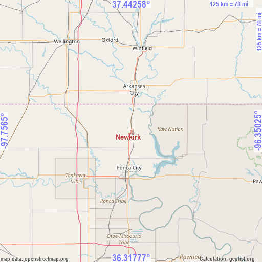
Newkirk GPS coordinates[2]
36° 52' 56.1" North, 97° 3' 12.132" West
| Map corner | latitude | longitude |
|---|---|---|
| Upper-left | 37.44258°, | -97.7565° |
| Center: | 36.88225°, | -97.05337° |
| Lower-right: | 36.31777°, | -96.35025° |
| Map W x H: | 125.1×125.1 km | = 77.7×77.7mi |
| max Lat: | 71.29058° ⇑66.6% North |
| Newkirk: | 36.88225° |
| min Lat: | ⇓33.4% South 19.06759° |
| min Long | Newkirk | max Long |
| -171.73463° | -97.05337° | -66.98998° |
| W 24.1%⇐ | ⇒75.9% E |
Elevation
Elevation of Newkirk is 357 m = 1171 ft, and this is 62.2 m = 204 ft above average elevation for this country.
| Max E: |
3189 m = 10463 ft | 19.6% |
| Newkirk | 357 m 1171 ft | |
| Avg. | 294.8 m = 967 ft | |
Min E: |
-60 m = -197 ft | 80.4% |
See also: United States elevation on elevation.city.
Geographical zone
Newkirk is located in North temperate zone (between Tropic of Cancer and the Arctic Circle). Distance of this Northern Tropic circle is 1495 km =928.9 mi to South.| Distance of | km | miles | from Newkirk |
|---|---|---|---|
| North Pole | 5906.1 | 3669.9 | to North |
| Arctic Circle | 3300.3 | 2050.7 | to North |
| Tropic Cancer | 1495 | 928.9 | to South |
| Equator | 4100.9 | 2548.2 | to South |


Nearby cities:
15 places around Newkirk: (largest is in red/bold)
• Arkansas City
20 km =12.4 mi,  3°
3°
• Belle Plaine
60.4 km =37.5 mi,  340°
340°
• Billings
52.5 km =32.6 mi,  221°
221°
• Blackwell
22.2 km =13.8 mi,  247°
247°
• Burden
54.7 km =34 mi,  28°
28°
• Caldwell
51.9 km =32.2 mi,  288°
288°
• Cedar Vale
55 km =34.2 mi,  63°
63°
• Fairfax
46.3 km =28.8 mi,  137°
137°
• McCord
22.7 km =14.1 mi,  176°
176°
• Oxford
44.8 km =27.8 mi,  346°
346°
• Ponca City
19.7 km =12.2 mi,  188°
188°
• Tonkawa
32.2 km =20 mi,  225°
225°
• Udall
56.4 km =35 mi, 354°
• Wellington
51.1 km =31.8 mi,  326°
326°
• Winfield
40.1 km =24.9 mi,  7°
7°
Sources, notices
• [Note1] Compared only with cities in United States existing in our database
• [Src1] Map data: © OpenStreetMap contributors (CC-BY-SA)
• [Src2] Other city data from geonames.org with taken over terms of usage.
• [Src3] Geographical zone / Annual Mean Temperature by Robert A. Rohde @ Wikipedia
