Campbellsville geodata
Campbellsville (Kentucky) is a seat of a second-order administrative division; located in United States in America/New_York (GMT-4) time zone. With population of 11,237 people, there are 4106 cities with bigger population in this country. Compared to other cities in United States, 64.7% of cities are located further ↑North; 55% of cities are located further ←West and 62.4% of cities have lower elevation than Campbellsville. Note1


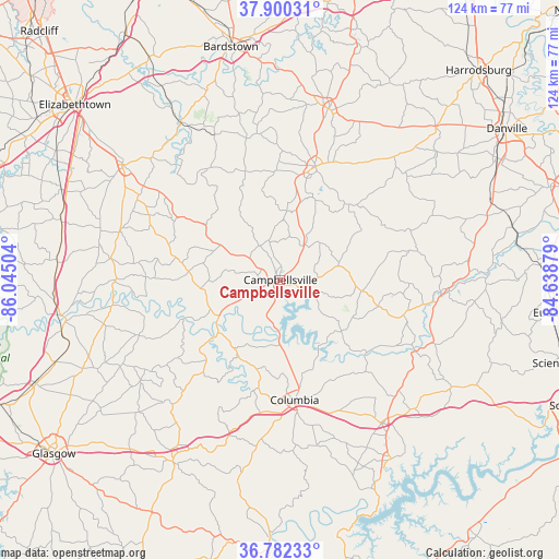
Campbellsville GPS coordinates[2]
37° 20' 36.24" North, 85° 20' 30.876" West
| Map corner | latitude | longitude |
|---|---|---|
| Upper-left | 37.90031°, | -86.04504° |
| Center: | 37.3434°, | -85.34191° |
| Lower-right: | 36.78233°, | -84.63879° |
| Map W x H: | 124.3×124.3 km | = 77.2×77.2mi |
| max Lat: | 71.29058° ⇑64.7% North |
| Campbellsville: | 37.3434° |
| min Lat: | ⇓35.3% South 19.06759° |
| min Long | Campbellsville | max Long |
| -171.73463° | -85.34191° | -66.98998° |
| W 55%⇐ | ⇒45% E |
Elevation
Elevation of Campbellsville is 250 m = 820 ft, and this is 44.8 m = 147 ft below average elevation for this country.
| Max E: |
3189 m = 10463 ft | 37.6% |
| Avg. | 294.8 m = 967 ft | |
| Campbellsville | 250 m = 820 ft | |
Min E: |
-60 m = -197 ft | 62.4% |
See also: United States elevation on elevation.city.
Geographical zone
Campbellsville is located in North temperate zone (between Tropic of Cancer and the Arctic Circle). Distance of this Northern Tropic circle is 1546.3 km =960.8 mi to South.| Distance of | km | miles | from Campbellsville |
|---|---|---|---|
| North Pole | 5854.9 | 3638.1 | to North |
| Arctic Circle | 3249 | 2018.8 | to North |
| Tropic Cancer | 1546.3 | 960.8 | to South |
| Equator | 4152.2 | 2580.1 | to South |


Nearby cities:
15 places around Campbellsville: (largest is in red/bold)
• Columbia
26.9 km =16.7 mi,  173°
173°
• Edmonton
47 km =29.2 mi,  210°
210°
• Greensburg
16.6 km =10.3 mi,  236°
236°
• Hodgenville
43.5 km =27 mi,  306°
306°
• Jamestown
46.9 km =29.1 mi,  148°
148°
• Lebanon
26.4 km =16.4 mi,  17°
17°
• Liberty
35.7 km =22.2 mi,  94°
94°
• Loretto
32.9 km =20.4 mi,  350°
350°
• Magnolia
37.2 km =23.1 mi,  287°
287°
• New Haven
41.3 km =25.7 mi,  327°
327°
• Perryville
48.5 km =30.1 mi,  45°
45°
• Russell Springs
39 km =24.2 mi,  144°
144°
• Salem
43.9 km =27.3 mi,  134°
134°
• Springfield
39.5 km =24.5 mi, 15°
• Summersville
18 km =11.2 mi,  263°
263°
Sources, notices
• [Note1] Compared only with cities in United States existing in our database
• [Src1] Map data: © OpenStreetMap contributors (CC-BY-SA)
• [Src2] Other city data from geonames.org with taken over terms of usage.
• [Src3] Geographical zone / Annual Mean Temperature by Robert A. Rohde @ Wikipedia
