Magnolia geodata
Magnolia (Kentucky) is a populated place; located in United States in America/New_York (GMT-4) time zone. With population of 524 people, there are 20579 cities with bigger population in this country. Compared to other cities in United States, 64.3% of cities are located further ↑North; 53.6% of cities are located further ←West and 65.2% of cities have lower elevation than Magnolia. Note1


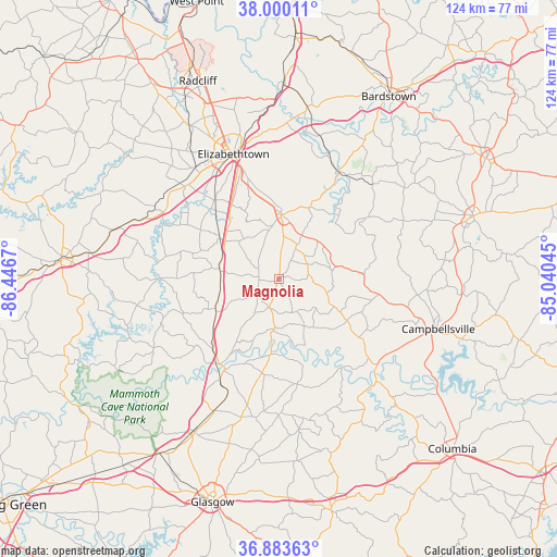
Magnolia GPS coordinates[2]
37° 26' 38.22" North, 85° 44' 36.852" West
| Map corner | latitude | longitude |
|---|---|---|
| Upper-left | 38.00011°, | -86.4467° |
| Center: | 37.44395°, | -85.74357° |
| Lower-right: | 36.88363°, | -85.04045° |
| Map W x H: | 124.1×124.1 km | = 77.1×77.1mi |
| max Lat: | 71.29058° ⇑64.3% North |
| Magnolia: | 37.44395° |
| min Lat: | ⇓35.7% South 19.06759° |
| min Long | Magnolia | max Long |
| -171.73463° | -85.74357° | -66.98998° |
| W 53.6%⇐ | ⇒46.4% E |
Elevation
Elevation of Magnolia is 263 m = 863 ft, and this is 31.8 m = 104 ft below average elevation for this country.
| Max E: |
3189 m = 10463 ft | 34.8% |
| Avg. | 294.8 m = 967 ft | |
| Magnolia | 263 m = 863 ft | |
Min E: |
-60 m = -197 ft | 65.2% |
See also: United States elevation on elevation.city.
Geographical zone
Magnolia is located in North temperate zone (between Tropic of Cancer and the Arctic Circle). Distance of this Northern Tropic circle is 1557.5 km =967.8 mi to South.| Distance of | km | miles | from Magnolia |
|---|---|---|---|
| North Pole | 5843.7 | 3631.1 | to North |
| Arctic Circle | 3237.8 | 2011.9 | to North |
| Tropic Cancer | 1557.5 | 967.8 | to South |
| Equator | 4163.4 | 2587 | to South |


Nearby cities:
15 places around Magnolia: (largest is in red/bold)
• Campbellsville
37.2 km =23.1 mi,  107°
107°
• Cave City
39 km =24.2 mi,  208°
208°
• Cecilia
31 km =19.3 mi,  322°
322°
• Clarkson
42.5 km =26.4 mi,  277°
277°
• Elizabethtown
29.6 km =18.4 mi,  339°
339°
• Greensburg
29.7 km =18.5 mi,  133°
133°
• Hodgenville
14.5 km =9 mi,  1°
1°
• Horse Cave
32.8 km =20.4 mi, 206°
• Lebanon
45.5 km =28.3 mi,  72°
72°
• Lebanon Junction
43.4 km =27 mi, 1°
• Loretto
37 km =23 mi,  54°
54°
• Munfordville
23.1 km =14.4 mi, 214°
• New Haven
27.3 km =17 mi,  29°
29°
• Summersville
21.9 km =13.6 mi, 126°
• Upton
13.4 km =8.3 mi, 280°
Sources, notices
• [Note1] Compared only with cities in United States existing in our database
• [Src1] Map data: © OpenStreetMap contributors (CC-BY-SA)
• [Src2] Other city data from geonames.org with taken over terms of usage.
• [Src3] Geographical zone / Annual Mean Temperature by Robert A. Rohde @ Wikipedia
