Edmonton geodata
Edmonton (Kentucky) is a seat of a second-order administrative division; located in United States in America/Chicago (GMT-5) time zone. With population of 1,568 people, there are 13408 cities with bigger population in this country. Compared to other cities in United States, 66.3% of cities are located further ↑North; 54.2% of cities are located further ←West and 63.5% of cities have lower elevation than Edmonton. Note1


Edmonton GPS coordinates[2]
36° 58' 48.216" North, 85° 36' 43.884" West
| Map corner | latitude | longitude |
|---|---|---|
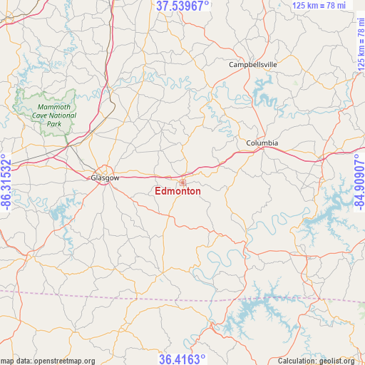
| Upper-left | 37.53967°, | -86.31532° |
| Center: | 36.98006°, | -85.61219° |
| Lower-right: | 36.4163°, | -84.90907° |
| Map W x H: | 124.9×124.9 km | = 77.6×77.6mi |
| max Lat: | 71.29058° ⇑66.3% North |
| Edmonton: | 36.98006° |
| min Lat: | ⇓33.7% South 19.06759° |
| min Long | Edmonton | max Long |
| -171.73463° | -85.61219° | -66.98998° |
| W 54.2%⇐ | ⇒45.8% E |
Elevation
Elevation of Edmonton is 255 m = 837 ft, and this is 39.8 m = 131 ft below average elevation for this country.
| Max E: |
3189 m = 10463 ft | 36.5% |
| Avg. | 294.8 m = 967 ft | |
| Edmonton | 255 m = 837 ft | |
Min E: |
-60 m = -197 ft | 63.5% |
See also: United States elevation on elevation.city.
Geographical zone
Edmonton is located in North temperate zone (between Tropic of Cancer and the Arctic Circle). Distance of this Northern Tropic circle is 1505.9 km =935.7 mi to South.| Distance of | km | miles | from Edmonton |
|---|---|---|---|
| North Pole | 5895.3 | 3663.2 | to North |
| Arctic Circle | 3289.4 | 2043.9 | to North |
| Tropic Cancer | 1505.9 | 935.7 | to South |
| Equator | 4111.8 | 2555 | to South |


Nearby cities:
15 places around Edmonton: (largest is in red/bold)
• Burkesville
30.1 km =18.7 mi,  134°
134°
• Campbellsville
47 km =29.2 mi,  30°
30°
• Cave City
35.2 km =21.9 mi,  299°
299°
• Celina
48.8 km =30.3 mi,  168°
168°
• Columbia
30.4 km =18.9 mi,  63°
63°
• Glasgow
26.7 km =16.6 mi,  273°
273°
• Greensburg
32.8 km =20.4 mi,  17°
17°
• Horse Cave
34.3 km =21.3 mi,  310°
310°
• Jamestown
48.8 km =30.3 mi,  89°
89°
• Magnolia
52.9 km =32.9 mi,  347°
347°
• Munfordville
40.8 km =25.4 mi,  322°
322°
• Park City
40.6 km =25.2 mi,  288°
288°
• Russell Springs
47.3 km =29.4 mi,  79°
79°
• Summersville
38.9 km =24.2 mi,  8°
8°
• Tompkinsville
31.7 km =19.7 mi,  192°
192°
Sources, notices
• [Note1] Compared only with cities in United States existing in our database
• [Src1] Map data: © OpenStreetMap contributors (CC-BY-SA)
• [Src2] Other city data from geonames.org with taken over terms of usage.
• [Src3] Geographical zone / Annual Mean Temperature by Robert A. Rohde @ Wikipedia
