Hodgenville geodata
Hodgenville (Kentucky) is a seat of a second-order administrative division; located in United States in America/New_York (GMT-4) time zone. With population of 3,256 people, there are 9215 cities with bigger population in this country. Compared to other cities in United States, 63.8% of cities are located further ↑North; 53.7% of cities are located further ←West and 55.8% of cities have lower elevation than Hodgenville. Note1


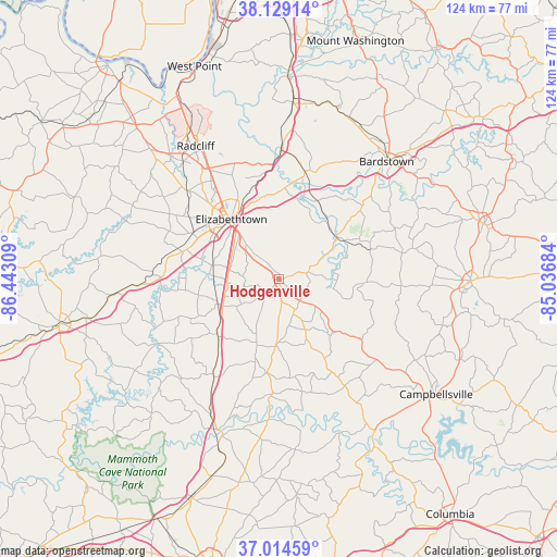
Hodgenville GPS coordinates[2]
37° 34' 26.22" North, 85° 44' 23.856" West
| Map corner | latitude | longitude |
|---|---|---|
| Upper-left | 38.12914°, | -86.44309° |
| Center: | 37.57395°, | -85.73996° |
| Lower-right: | 37.01459°, | -85.03684° |
| Map W x H: | 123.9×123.9 km | = 77×77mi |
| max Lat: | 71.29058° ⇑63.8% North |
| Hodgenville: | 37.57395° |
| min Lat: | ⇓36.2% South 19.06759° |
| min Long | Hodgenville | max Long |
| -171.73463° | -85.73996° | -66.98998° |
| W 53.7%⇐ | ⇒46.3% E |
Elevation
Elevation of Hodgenville is 222 m = 728 ft, and this is 72.8 m = 239 ft below average elevation for this country.
| Max E: |
3189 m = 10463 ft | 44.2% |
| Avg. | 294.8 m = 967 ft | |
| Hodgenville | 222 m = 728 ft | |
Min E: |
-60 m = -197 ft | 55.8% |
See also: United States elevation on elevation.city.
Geographical zone
Hodgenville is located in North temperate zone (between Tropic of Cancer and the Arctic Circle). Distance of this Northern Tropic circle is 1571.9 km =976.7 mi to South.| Distance of | km | miles | from Hodgenville |
|---|---|---|---|
| North Pole | 5829.2 | 3622.1 | to North |
| Arctic Circle | 3223.3 | 2002.9 | to North |
| Tropic Cancer | 1571.9 | 976.7 | to South |
| Equator | 4177.8 | 2596 | to South |


Nearby cities:
15 places around Hodgenville: (largest is in red/bold)
• Bardstown
35.5 km =22.1 mi,  42°
42°
• Cecilia
21.6 km =13.4 mi,  298°
298°
• Elizabethtown
17 km =10.6 mi,  321°
321°
• Fort Knox
40.4 km =25.1 mi,  330°
330°
• Greensburg
40.8 km =25.4 mi,  148°
148°
• Lebanon
42.9 km =26.7 mi,  90°
90°
• Lebanon Junction
29 km =18 mi,  1°
1°
• Loretto
30.6 km =19 mi,  77°
77°
• Magnolia
14.5 km =9 mi,  181°
181°
• Munfordville
36.1 km =22.4 mi,  201°
201°
• New Haven
16.1 km =10 mi,  54°
54°
• Radcliff
34.9 km =21.7 mi, 328°
• Summersville
32.5 km =20.2 mi, 147°
• Upton
18.2 km =11.3 mi,  228°
228°
• Vine Grove
33.8 km =21 mi, 321°
Sources, notices
• [Note1] Compared only with cities in United States existing in our database
• [Src1] Map data: © OpenStreetMap contributors (CC-BY-SA)
• [Src2] Other city data from geonames.org with taken over terms of usage.
• [Src3] Geographical zone / Annual Mean Temperature by Robert A. Rohde @ Wikipedia
