Smiths Grove geodata
Smiths Grove (Kentucky) is a populated place; located in United States in America/Chicago (GMT-5) time zone. With population of 736 people, there are 18345 cities with bigger population in this country. Compared to other cities in United States, 65.9% of cities are located further ↑North; 52.3% of cities are located further ←West and 50.5% of cities have higher elevation than Smiths Grove. Note1


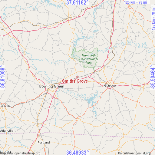
Smiths Grove GPS coordinates[2]
37° 3' 9.18" North, 86° 12' 27.936" West
| Map corner | latitude | longitude |
|---|---|---|
| Upper-left | 37.61162°, | -86.91089° |
| Center: | 37.05255°, | -86.20776° |
| Lower-right: | 36.48933°, | -85.50464° |
| Map W x H: | 124.8×124.8 km | = 77.5×77.5mi |
| max Lat: | 71.29058° ⇑65.9% North |
| Smiths Grove: | 37.05255° |
| min Lat: | ⇓34.1% South 19.06759° |
| min Long | Smiths Grove | max Long |
| -171.73463° | -86.20776° | -66.98998° |
| W 52.3%⇐ | ⇒47.7% E |
Elevation
Elevation of Smiths Grove is 196 m = 643 ft, and this is 98.8 m = 324 ft below average elevation for this country.
| Max E: |
3189 m = 10463 ft | 50.5% |
| Avg. | 294.8 m = 967 ft | |
| Smiths Grove | 196 m = 643 ft | |
Min E: |
-60 m = -197 ft | 49.5% |
See also: United States elevation on elevation.city.
Geographical zone
Smiths Grove is located in North temperate zone (between Tropic of Cancer and the Arctic Circle). Distance of this Northern Tropic circle is 1513.9 km =940.7 mi to South.| Distance of | km | miles | from Smiths Grove |
|---|---|---|---|
| North Pole | 5887.2 | 3658.1 | to North |
| Arctic Circle | 3281.3 | 2038.9 | to North |
| Tropic Cancer | 1513.9 | 940.7 | to South |
| Equator | 4119.9 | 2560 | to South |


Nearby cities:
15 places around Smiths Grove: (largest is in red/bold)
• Auburn
49.3 km =30.6 mi,  244°
244°
• Bowling Green
22.1 km =13.7 mi,  251°
251°
• Brownsville
16.5 km =10.3 mi,  341°
341°
• Caneyville
48.2 km =30 mi,  328°
328°
• Cave City
24.1 km =15 mi,  67°
67°
• Clarkson
49.2 km =30.6 mi,  358°
358°
• Franklin
49.3 km =30.6 mi,  221°
221°
• Glasgow
27 km =16.8 mi,  103°
103°
• Horse Cave
30.2 km =18.8 mi,  62°
62°
• Leitchfield
48.1 km =29.9 mi,  350°
350°
• Morgantown
46.4 km =28.8 mi,  294°
294°
• Munfordville
37.2 km =23.1 mi,  48°
48°
• Park City
15 km =9.3 mi, 72°
• Plano
26.8 km =16.7 mi, 224°
• Scottsville
33.3 km =20.7 mi,  177°
177°
Sources, notices
• [Note1] Compared only with cities in United States existing in our database
• [Src1] Map data: © OpenStreetMap contributors (CC-BY-SA)
• [Src2] Other city data from geonames.org with taken over terms of usage.
• [Src3] Geographical zone / Annual Mean Temperature by Robert A. Rohde @ Wikipedia
