Upton geodata
Upton (Kentucky) is a populated place; located in United States in America/New_York (GMT-4) time zone. With population of 665 people, there are 19022 cities with bigger population in this country. Compared to other cities in United States, 64.2% of cities are located further ↑North; 53.1% of cities are located further ←West and 56.9% of cities have lower elevation than Upton. Note1


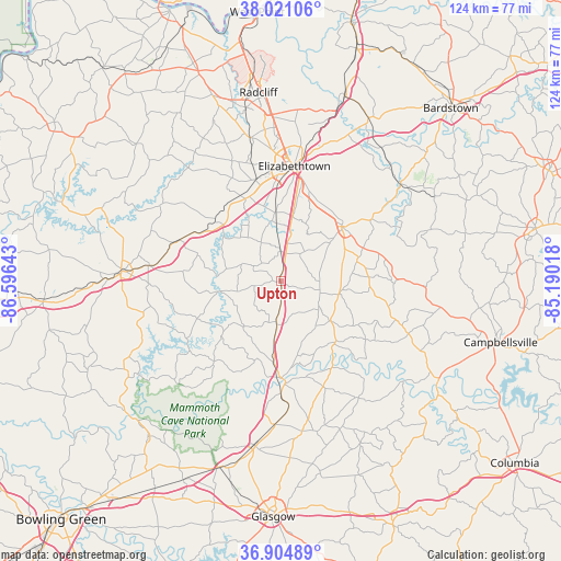
Upton GPS coordinates[2]
37° 27' 54.216" North, 85° 53' 35.88" West
| Map corner | latitude | longitude |
|---|---|---|
| Upper-left | 38.02106°, | -86.59643° |
| Center: | 37.46506°, | -85.8933° |
| Lower-right: | 36.90489°, | -85.19018° |
| Map W x H: | 124.1×124.1 km | = 77.1×77.1mi |
| max Lat: | 71.29058° ⇑64.2% North |
| Upton: | 37.46506° |
| min Lat: | ⇓35.8% South 19.06759° |
| min Long | Upton | max Long |
| -171.73463° | -85.8933° | -66.98998° |
| W 53.1%⇐ | ⇒46.9% E |
Elevation
Elevation of Upton is 226 m = 741 ft, and this is 68.8 m = 226 ft below average elevation for this country.
| Max E: |
3189 m = 10463 ft | 43.1% |
| Avg. | 294.8 m = 967 ft | |
| Upton | 226 m = 741 ft | |
Min E: |
-60 m = -197 ft | 56.9% |
See also: United States elevation on elevation.city.
Geographical zone
Upton is located in North temperate zone (between Tropic of Cancer and the Arctic Circle). Distance of this Northern Tropic circle is 1559.8 km =969.2 mi to South.| Distance of | km | miles | from Upton |
|---|---|---|---|
| North Pole | 5841.3 | 3629.6 | to North |
| Arctic Circle | 3235.4 | 2010.4 | to North |
| Tropic Cancer | 1559.8 | 969.2 | to South |
| Equator | 4165.7 | 2588.4 | to South |


Nearby cities:
15 places around Upton: (largest is in red/bold)
• Cave City
36.9 km =22.9 mi,  188°
188°
• Cecilia
23 km =14.3 mi,  345°
345°
• Clarkson
29.1 km =18.1 mi,  276°
276°
• Elizabethtown
25.6 km =15.9 mi,  6°
6°
• Greensburg
41.6 km =25.8 mi,  123°
123°
• Hodgenville
18.2 km =11.3 mi,  48°
48°
• Horse Cave
31.8 km =19.8 mi,  182°
182°
• Leitchfield
35.4 km =22 mi,  272°
272°
• Magnolia
13.4 km =8.3 mi,  100°
100°
• Munfordville
21.4 km =13.3 mi, 179°
• New Haven
34.2 km =21.3 mi, 51°
• Park City
43.4 km =27 mi,  198°
198°
• Radcliff
42 km =26.1 mi, 353°
• Summersville
34.5 km =21.4 mi, 116°
• Vine Grove
39.1 km =24.3 mi, 348°
Sources, notices
• [Note1] Compared only with cities in United States existing in our database
• [Src1] Map data: © OpenStreetMap contributors (CC-BY-SA)
• [Src2] Other city data from geonames.org with taken over terms of usage.
• [Src3] Geographical zone / Annual Mean Temperature by Robert A. Rohde @ Wikipedia
