Lexington-Fayette geodata
Lexington-Fayette (Kentucky) is a populated place; located in United States in America/New_York (GMT-4) time zone. With population of 314,488 people, there are 67 cities with bigger population in this country. Compared to other cities in United States, 61.3% of cities are located further ↑North; 57.6% of cities are located further ←West and 73.5% of cities have lower elevation than Lexington-Fayette. Note1


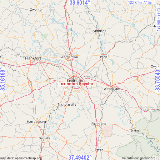
Lexington-Fayette GPS coordinates[2]
38° 2' 59.28" North, 84° 27' 30.78" West
| Map corner | latitude | longitude |
|---|---|---|
| Upper-left | 38.6014°, | -85.16168° |
| Center: | 38.0498°, | -84.45855° |
| Lower-right: | 37.49402°, | -83.75543° |
| Map W x H: | 123.1×123.1 km | = 76.5×76.5mi |
| max Lat: | 71.29058° ⇑61.3% North |
| Lexington-Fayette: | 38.0498° |
| min Lat: | ⇓38.7% South 19.06759° |
| min Long | Lexington-Fayet | max Long |
| -171.73463° | -84.45855° | -66.98998° |
| W 57.6%⇐ | ⇒42.4% E |
Elevation
Elevation of Lexington-Fayette is 304 m = 997 ft, and this is 9.2 m = 30 ft above average elevation for this country.
| Max E: |
3189 m = 10463 ft | 26.5% |
| Lexington-Fayette | 304 m 997 ft | |
| Avg. | 294.8 m = 967 ft | |
Min E: |
-60 m = -197 ft | 73.5% |
See also: Lexington-Fayette elevation on elevation.city.
Geographical zone
Lexington-Fayette is located in North temperate zone (between Tropic of Cancer and the Arctic Circle). Distance of this Northern Tropic circle is 1624.8 km =1009.6 mi to South.| Distance of | km | miles | from Lexington-Fayette |
|---|---|---|---|
| North Pole | 5776.3 | 3589.2 | to North |
| Arctic Circle | 3170.4 | 1970 | to North |
| Tropic Cancer | 1624.8 | 1009.6 | to South |
| Equator | 4230.7 | 2628.8 | to South |


Nearby cities:
15 places around Lexington-Fayette: (largest is in red/bold)
• Georgetown
19.8 km =12.3 mi,  333°
333°
• Lawrenceburg
38.4 km =23.9 mi,  267°
267°
• Lexington
7 km =4.3 mi,  193°
193°
• Midway
22.7 km =14.1 mi,  299°
299°
• Millersburg
39.1 km =24.3 mi,  44°
44°
• Monticello
10.3 km =6.4 mi,  231°
231°
• Mount Vernon
4.2 km =2.6 mi, 230°
• Nicholasville
21.3 km =13.2 mi,  208°
208°
• North Middletown
32.2 km =20 mi,  70°
70°
• Paris
25.3 km =15.7 mi,  45°
45°
• Richmond
36.5 km =22.7 mi,  156°
156°
• Stamping Ground
31.7 km =19.7 mi,  321°
321°
• Versailles
23.8 km =14.8 mi, 270°
• Wilmore
27.4 km =17 mi,  220°
220°
• Winchester
25.3 km =15.7 mi,  105°
105°
Sources, notices
• [Note1] Compared only with cities in United States existing in our database
• [Src1] Map data: © OpenStreetMap contributors (CC-BY-SA)
• [Src2] Other city data from geonames.org with taken over terms of usage.
• [Src3] Geographical zone / Annual Mean Temperature by Robert A. Rohde @ Wikipedia
