Stamping Ground geodata
Stamping Ground (Kentucky) is a populated place; located in United States in America/New_York (GMT-4) time zone. With population of 730 people, there are 18398 cities with bigger population in this country. Compared to other cities in United States, 60.1% of cities are located further ↑North; 56.7% of cities are located further ←West and 60.3% of cities have lower elevation than Stamping Ground. Note1


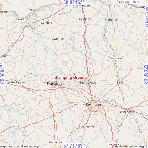
Stamping Ground GPS coordinates[2]
38° 16' 18.264" North, 84° 41' 10.824" West
| Map corner | latitude | longitude |
|---|---|---|
| Upper-left | 38.82165°, | -85.38947° |
| Center: | 38.27174°, | -84.68634° |
| Lower-right: | 37.71763°, | -83.98322° |
| Map W x H: | 122.8×122.8 km | = 76.3×76.3mi |
| max Lat: | 71.29058° ⇑60.1% North |
| Stamping Ground: | 38.27174° |
| min Lat: | ⇓39.9% South 19.06759° |
| min Long | Stamping Ground | max Long |
| -171.73463° | -84.68634° | -66.98998° |
| W 56.7%⇐ | ⇒43.3% E |
Elevation
Elevation of Stamping Ground is 241 m = 791 ft, and this is 53.8 m = 177 ft below average elevation for this country.
| Max E: |
3189 m = 10463 ft | 39.7% |
| Avg. | 294.8 m = 967 ft | |
| Stamping Ground | 241 m = 791 ft | |
Min E: |
-60 m = -197 ft | 60.3% |
See also: United States elevation on elevation.city.
Geographical zone
Stamping Ground is located in North temperate zone (between Tropic of Cancer and the Arctic Circle). Distance of this Northern Tropic circle is 1649.5 km =1025 mi to South.| Distance of | km | miles | from Stamping Ground |
|---|---|---|---|
| North Pole | 5751.6 | 3573.9 | to North |
| Arctic Circle | 3145.8 | 1954.7 | to North |
| Tropic Cancer | 1649.5 | 1025 | to South |
| Equator | 4255.4 | 2644.2 | to South |


Nearby cities:
15 places around Stamping Ground: (largest is in red/bold)
• Bromley
43.4 km =27 mi,  341°
341°
• Cynthiana
36.7 km =22.8 mi,  68°
68°
• Frankfort
18.1 km =11.2 mi,  244°
244°
• Georgetown
13.1 km =8.1 mi,  121°
121°
• Lawrenceburg
31.9 km =19.8 mi,  215°
215°
• Lexington
36.4 km =22.6 mi,  149°
149°
• Lexington-Fayette
31.7 km =19.7 mi,  141°
141°
• Midway
13.4 km =8.3 mi,  179°
179°
• Monticello
33.3 km =20.7 mi,  159°
159°
• Mount Vernon
32.1 km =19.9 mi, 148°
• Owenton
32.5 km =20.2 mi, 335°
• Paris
38.5 km =23.9 mi,  100°
100°
• Pleasureville
38.3 km =23.8 mi,  282°
282°
• Versailles
24.7 km =15.3 mi,  188°
188°
• Williamstown
42.2 km =26.2 mi,  15°
15°
Sources, notices
• [Note1] Compared only with cities in United States existing in our database
• [Src1] Map data: © OpenStreetMap contributors (CC-BY-SA)
• [Src2] Other city data from geonames.org with taken over terms of usage.
• [Src3] Geographical zone / Annual Mean Temperature by Robert A. Rohde @ Wikipedia
