Munfordville geodata
Munfordville (Kentucky) is a seat of a second-order administrative division; located in United States in America/Chicago (GMT-5) time zone. With population of 1,640 people, there are 13125 cities with bigger population in this country. Compared to other cities in United States, 65% of cities are located further ↑North; 53.2% of cities are located further ←West and 51.9% of cities have higher elevation than Munfordville. Note1


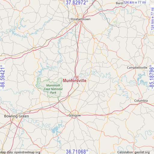
Munfordville GPS coordinates[2]
37° 16' 20.208" North, 85° 53' 27.888" West
| Map corner | latitude | longitude |
|---|---|---|
| Upper-left | 37.82972°, | -86.59421° |
| Center: | 37.27228°, | -85.89108° |
| Lower-right: | 36.71068°, | -85.18796° |
| Map W x H: | 124.4×124.4 km | = 77.3×77.3mi |
| max Lat: | 71.29058° ⇑65% North |
| Munfordville: | 37.27228° |
| min Lat: | ⇓35% South 19.06759° |
| min Long | Munfordville | max Long |
| -171.73463° | -85.89108° | -66.98998° |
| W 53.2%⇐ | ⇒46.8% E |
Elevation
Elevation of Munfordville is 191 m = 627 ft, and this is 103.8 m = 341 ft below average elevation for this country.
| Max E: |
3189 m = 10463 ft | 51.9% |
| Avg. | 294.8 m = 967 ft | |
| Munfordville | 191 m = 627 ft | |
Min E: |
-60 m = -197 ft | 48.1% |
See also: United States elevation on elevation.city.
Geographical zone
Munfordville is located in North temperate zone (between Tropic of Cancer and the Arctic Circle). Distance of this Northern Tropic circle is 1538.4 km =955.9 mi to South.| Distance of | km | miles | from Munfordville |
|---|---|---|---|
| North Pole | 5862.8 | 3643 | to North |
| Arctic Circle | 3256.9 | 2023.7 | to North |
| Tropic Cancer | 1538.4 | 955.9 | to South |
| Equator | 4144.3 | 2575.1 | to South |


Nearby cities:
15 places around Munfordville: (largest is in red/bold)
• Brownsville
34.5 km =21.4 mi,  255°
255°
• Cave City
16.2 km =10.1 mi,  201°
201°
• Cecilia
44.1 km =27.4 mi,  352°
352°
• Clarkson
38.3 km =23.8 mi,  310°
310°
• Edmonton
40.8 km =25.4 mi,  142°
142°
• Glasgow
30.8 km =19.1 mi,  183°
183°
• Greensburg
34.7 km =21.6 mi,  92°
92°
• Hodgenville
36.1 km =22.4 mi,  21°
21°
• Horse Cave
10.4 km =6.5 mi,  187°
187°
• Leitchfield
42.4 km =26.3 mi,  302°
302°
• Magnolia
23.1 km =14.4 mi,  34°
34°
• Park City
24.1 km =15 mi,  214°
214°
• Smiths Grove
37.2 km =23.1 mi,  228°
228°
• Summersville
31.2 km =19.4 mi,  78°
78°
• Upton
21.4 km =13.3 mi,  359°
359°
Sources, notices
• [Note1] Compared only with cities in United States existing in our database
• [Src1] Map data: © OpenStreetMap contributors (CC-BY-SA)
• [Src2] Other city data from geonames.org with taken over terms of usage.
• [Src3] Geographical zone / Annual Mean Temperature by Robert A. Rohde @ Wikipedia
