Glasgow geodata
Glasgow (Kentucky) is a seat of a second-order administrative division; located in United States in America/Chicago (GMT-5) time zone. With population of 14,470 people, there are 3345 cities with bigger population in this country. Compared to other cities in United States, 66.1% of cities are located further ↑North; 53.1% of cities are located further ←West and 57.5% of cities have lower elevation than Glasgow. Note1


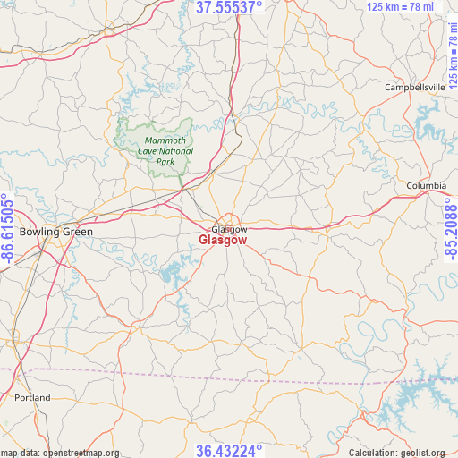
Glasgow GPS coordinates[2]
36° 59' 45.168" North, 85° 54' 42.912" West
| Map corner | latitude | longitude |
|---|---|---|
| Upper-left | 37.55537°, | -86.61505° |
| Center: | 36.99588°, | -85.91192° |
| Lower-right: | 36.43224°, | -85.2088° |
| Map W x H: | 124.9×124.9 km | = 77.6×77.6mi |
| max Lat: | 71.29058° ⇑66.1% North |
| Glasgow: | 36.99588° |
| min Lat: | ⇓33.9% South 19.06759° |
| min Long | Glasgow | max Long |
| -171.73463° | -85.91192° | -66.98998° |
| W 53.1%⇐ | ⇒46.9% E |
Elevation
Elevation of Glasgow is 228 m = 748 ft, and this is 66.8 m = 219 ft below average elevation for this country.
| Max E: |
3189 m = 10463 ft | 42.5% |
| Avg. | 294.8 m = 967 ft | |
| Glasgow | 228 m = 748 ft | |
Min E: |
-60 m = -197 ft | 57.5% |
See also: United States elevation on elevation.city.
Geographical zone
Glasgow is located in North temperate zone (between Tropic of Cancer and the Arctic Circle). Distance of this Northern Tropic circle is 1507.6 km =936.8 mi to South.| Distance of | km | miles | from Glasgow |
|---|---|---|---|
| North Pole | 5893.5 | 3662 | to North |
| Arctic Circle | 3287.6 | 2042.8 | to North |
| Tropic Cancer | 1507.6 | 936.8 | to South |
| Equator | 4113.6 | 2556.1 | to South |


Nearby cities:
15 places around Glasgow: (largest is in red/bold)
• Bowling Green
47.2 km =29.3 mi,  269°
269°
• Brownsville
38.4 km =23.9 mi,  304°
304°
• Cave City
16.2 km =10.1 mi,  345°
345°
• Edmonton
26.7 km =16.6 mi,  93°
93°
• Greensburg
47 km =29.2 mi,  51°
51°
• Horse Cave
20.4 km =12.7 mi,  1°
1°
• Magnolia
52 km =32.3 mi,  16°
16°
• Munfordville
30.8 km =19.1 mi, 3°
• Park City
16.2 km =10.1 mi,  312°
312°
• Plano
46.8 km =29.1 mi,  254°
254°
• Red Boiling Springs
51.7 km =32.1 mi,  173°
173°
• Scottsville
36.6 km =22.7 mi,  222°
222°
• Smiths Grove
27 km =16.8 mi,  283°
283°
• Summersville
49.1 km =30.5 mi,  41°
41°
• Tompkinsville
38.1 km =23.7 mi,  149°
149°
Sources, notices
• [Note1] Compared only with cities in United States existing in our database
• [Src1] Map data: © OpenStreetMap contributors (CC-BY-SA)
• [Src2] Other city data from geonames.org with taken over terms of usage.
• [Src3] Geographical zone / Annual Mean Temperature by Robert A. Rohde @ Wikipedia
