Celina geodata
Celina (Tennessee) is a seat of a second-order administrative division; located in United States in America/Chicago (GMT-5) time zone. With population of 1,494 people, there are 13679 cities with bigger population in this country. Compared to other cities in United States, 67.9% of cities are located further ↑North; 54.6% of cities are located further ←West and 57.3% of cities have higher elevation than Celina. Note1


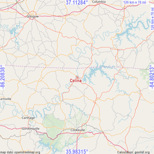
Celina GPS coordinates[2]
36° 33' 0.216" North, 85° 30' 18.9" West
| Map corner | latitude | longitude |
|---|---|---|
| Upper-left | 37.11284°, | -86.20838° |
| Center: | 36.55006°, | -85.50525° |
| Lower-right: | 35.98315°, | -84.80213° |
| Map W x H: | 125.6×125.6 km | = 78×78mi |
| max Lat: | 71.29058° ⇑67.9% North |
| Celina: | 36.55006° |
| min Lat: | ⇓32.1% South 19.06759° |
| min Long | Celina | max Long |
| -171.73463° | -85.50525° | -66.98998° |
| W 54.6%⇐ | ⇒45.4% E |
Elevation
Elevation of Celina is 169 m = 554 ft, and this is 125.8 m = 413 ft below average elevation for this country.
| Max E: |
3189 m = 10463 ft | 57.3% |
| Avg. | 294.8 m = 967 ft | |
| Celina | 169 m = 554 ft | |
Min E: |
-60 m = -197 ft | 42.7% |
See also: United States elevation on elevation.city.
Geographical zone
Celina is located in North temperate zone (between Tropic of Cancer and the Arctic Circle). Distance of this Northern Tropic circle is 1458.1 km =906 mi to South.| Distance of | km | miles | from Celina |
|---|---|---|---|
| North Pole | 5943.1 | 3692.9 | to North |
| Arctic Circle | 3337.2 | 2073.6 | to North |
| Tropic Cancer | 1458.1 | 906 | to South |
| Equator | 4064 | 2525.3 | to South |


Nearby cities:
15 places around Celina: (largest is in red/bold)
• Albany
36.6 km =22.7 mi,  64°
64°
• Algood
39.7 km =24.7 mi,  172°
172°
• Baxter
45.8 km =28.5 mi,  195°
195°
• Burkesville
29.3 km =18.2 mi,  24°
24°
• Byrdstown
33.7 km =20.9 mi,  85°
85°
• Cookeville
43.1 km =26.8 mi,  179°
179°
• Dodson Branch
26.5 km =16.5 mi,  185°
185°
• Edmonton
48.8 km =30.3 mi,  348°
348°
• Gainesboro
25.6 km =15.9 mi,  212°
212°
• Lafayette
44.7 km =27.8 mi, 204°
• Lafayette
46.7 km =29 mi,  266°
266°
• Livingston
24.7 km =15.3 mi,  138°
138°
• Monterey
49.5 km =30.8 mi,  154°
154°
• Red Boiling Springs
30.9 km =19.2 mi, 266°
• Tompkinsville
23.7 km =14.7 mi,  315°
315°
Sources, notices
• [Note1] Compared only with cities in United States existing in our database
• [Src1] Map data: © OpenStreetMap contributors (CC-BY-SA)
• [Src2] Other city data from geonames.org with taken over terms of usage.
• [Src3] Geographical zone / Annual Mean Temperature by Robert A. Rohde @ Wikipedia
