Greenwood geodata
Greenwood (Louisiana) is a populated place; located in United States in America/Chicago (GMT-5) time zone. With population of 3,191 people, there are 9314 cities with bigger population in this country. Compared to other cities in United States, 87.3% of cities are located further ↑North; 68.6% of cities are located further →East and 73.3% of cities have higher elevation than Greenwood. Note1


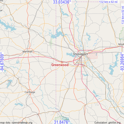
Greenwood GPS coordinates[2]
32° 26' 34.548" North, 93° 58' 22.656" West
| Map corner | latitude | longitude |
|---|---|---|
| Upper-left | 33.03436°, | -94.67609° |
| Center: | 32.44293°, | -93.97296° |
| Lower-right: | 31.8476°, | -93.26984° |
| Map W x H: | 132×132 km | = 82×82mi |
| max Lat: | 71.29058° ⇑87.3% North |
| Greenwood: | 32.44293° |
| min Lat: | ⇓12.7% South 19.06759° |
| min Long | Greenwood | max Long |
| -171.73463° | -93.97296° | -66.98998° |
| W 31.4%⇐ | ⇒68.6% E |
Elevation
Elevation of Greenwood is 81 m = 266 ft, and this is 213.8 m = 701 ft below average elevation for this country.
| Max E: |
3189 m = 10463 ft | 73.3% |
| Avg. | 294.8 m = 967 ft | |
| Greenwood | 81 m = 266 ft | |
Min E: |
-60 m = -197 ft | 26.7% |
See also: United States elevation on elevation.city.
Geographical zone
Greenwood is located in North temperate zone (between Tropic of Cancer and the Arctic Circle). Distance of this Northern Tropic circle is 1001.4 km =622.2 mi to South.| Distance of | km | miles | from Greenwood |
|---|---|---|---|
| North Pole | 6399.7 | 3976.6 | to North |
| Arctic Circle | 3793.9 | 2357.4 | to North |
| Tropic Cancer | 1001.4 | 622.2 | to South |
| Equator | 3607.3 | 2241.5 | to South |


Nearby cities:
15 places around Greenwood: (largest is in red/bold)
• Benton
35.4 km =22 mi,  37°
37°
• Blanchard
17.1 km =10.6 mi,  26°
26°
• Bossier City
24 km =14.9 mi,  70°
70°
• Carthage
46.7 km =29 mi,  227°
227°
• Eastwood
40.1 km =24.9 mi, 71°
• Haughton
45.1 km =28 mi,  77°
77°
• Lakeview
16.2 km =10.1 mi,  56°
56°
• Marshall
38.7 km =24 mi,  287°
287°
• Mooringsport
27.2 km =16.9 mi,  2°
2°
• Oil City
33.5 km =20.8 mi, 0°
• Red Chute
36 km =22.4 mi, 69°
• Shreveport
22.8 km =14.2 mi, 66°
• Stonewall
22.7 km =14.1 mi,  142°
142°
• Vivian
47.7 km =29.6 mi,  358°
358°
• Waskom
9.1 km =5.7 mi,  296°
296°
Sources, notices
• [Note1] Compared only with cities in United States existing in our database
• [Src1] Map data: © OpenStreetMap contributors (CC-BY-SA)
• [Src2] Other city data from geonames.org with taken over terms of usage.
• [Src3] Geographical zone / Annual Mean Temperature by Robert A. Rohde @ Wikipedia
