Stonewall geodata
Stonewall (Louisiana) is a populated place; located in United States in America/Chicago (GMT-5) time zone. With population of 2,093 people, there are 11646 cities with bigger population in this country. Compared to other cities in United States, 87.9% of cities are located further ↑North; 68.3% of cities are located further →East and 74.6% of cities have higher elevation than Stonewall. Note1


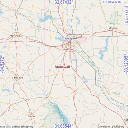
Stonewall GPS coordinates[2]
32° 16' 54.588" North, 93° 49' 26.652" West
| Map corner | latitude | longitude |
|---|---|---|
| Upper-left | 32.87432°, | -94.5272° |
| Center: | 32.28183°, | -93.82407° |
| Lower-right: | 31.68544°, | -93.12095° |
| Map W x H: | 132.2×132.2 km | = 82.1×82.1mi |
| max Lat: | 71.29058° ⇑87.9% North |
| Stonewall: | 32.28183° |
| min Lat: | ⇓12.1% South 19.06759° |
| min Long | Stonewall | max Long |
| -171.73463° | -93.82407° | -66.98998° |
| W 31.7%⇐ | ⇒68.3% E |
Elevation
Elevation of Stonewall is 74 m = 243 ft, and this is 220.8 m = 724 ft below average elevation for this country.
| Max E: |
3189 m = 10463 ft | 74.6% |
| Avg. | 294.8 m = 967 ft | |
| Stonewall | 74 m = 243 ft | |
Min E: |
-60 m = -197 ft | 25.4% |
See also: United States elevation on elevation.city.
Geographical zone
Stonewall is located in North temperate zone (between Tropic of Cancer and the Arctic Circle). Distance of this Northern Tropic circle is 983.5 km =611.1 mi to South.| Distance of | km | miles | from Stonewall |
|---|---|---|---|
| North Pole | 6417.7 | 3987.8 | to North |
| Arctic Circle | 3811.8 | 2368.5 | to North |
| Tropic Cancer | 983.5 | 611.1 | to South |
| Equator | 3589.4 | 2230.3 | to South |


Nearby cities:
15 places around Stonewall: (largest is in red/bold)
• Benton
46.6 km =29 mi,  9°
9°
• Blanchard
33.9 km =21.1 mi,  349°
349°
• Bossier City
27.4 km =17 mi,  18°
18°
• Doyline
48 km =29.8 mi,  53°
53°
• Eastwood
38.9 km =24.2 mi,  38°
38°
• Greenwood
22.7 km =14.1 mi,  322°
322°
• Haughton
41 km =25.5 mi, 47°
• Joaquin
41.3 km =25.7 mi,  211°
211°
• Lakeview
26.8 km =16.7 mi,  358°
358°
• Logansport
37.8 km =23.5 mi, 205°
• Mansfield
29.5 km =18.3 mi,  156°
156°
• Mooringsport
46.9 km =29.1 mi,  344°
344°
• Red Chute
36.3 km =22.6 mi,  32°
32°
• Shreveport
27.9 km =17.3 mi, 14°
• Waskom
31.1 km =19.3 mi,  314°
314°
Sources, notices
• [Note1] Compared only with cities in United States existing in our database
• [Src1] Map data: © OpenStreetMap contributors (CC-BY-SA)
• [Src2] Other city data from geonames.org with taken over terms of usage.
• [Src3] Geographical zone / Annual Mean Temperature by Robert A. Rohde @ Wikipedia
