Shreveport geodata
Shreveport (Louisiana) is a seat of a second-order administrative division; located in United States in America/Chicago (GMT-5) time zone. With population of 197,204 people, there are 133 cities with bigger population in this country. Compared to other cities in United States, 87% of cities are located further ↑North; 68.1% of cities are located further →East and 79.3% of cities have higher elevation than Shreveport. Note1


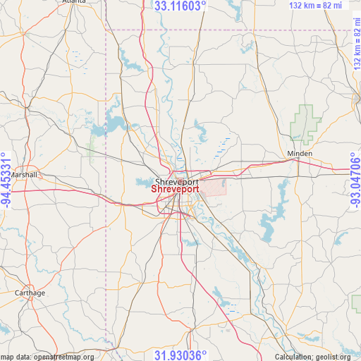
Shreveport GPS coordinates[2]
32° 31' 30.54" North, 93° 45' 0.648" West
| Map corner | latitude | longitude |
|---|---|---|
| Upper-left | 33.11603°, | -94.45331° |
| Center: | 32.52515°, | -93.75018° |
| Lower-right: | 31.93036°, | -93.04706° |
| Map W x H: | 131.8×131.8 km | = 81.9×81.9mi |
| max Lat: | 71.29058° ⇑87% North |
| Shreveport: | 32.52515° |
| min Lat: | ⇓13% South 19.06759° |
| min Long | Shreveport | max Long |
| -171.73463° | -93.75018° | -66.98998° |
| W 31.9%⇐ | ⇒68.1% E |
Elevation
Elevation of Shreveport is 50 m = 164 ft, and this is 244.8 m = 803 ft below average elevation for this country.
| Max E: |
3189 m = 10463 ft | 79.3% |
| Avg. | 294.8 m = 967 ft | |
| Shreveport | 50 m = 164 ft | |
Min E: |
-60 m = -197 ft | 20.7% |
See also: Shreveport elevation on elevation.city.
Geographical zone
Shreveport is located in North temperate zone (between Tropic of Cancer and the Arctic Circle). Distance of this Northern Tropic circle is 1010.5 km =627.9 mi to South.| Distance of | km | miles | from Shreveport |
|---|---|---|---|
| North Pole | 6390.6 | 3970.9 | to North |
| Arctic Circle | 3784.7 | 2351.7 | to North |
| Tropic Cancer | 1010.5 | 627.9 | to South |
| Equator | 3616.5 | 2247.2 | to South |


Nearby cities:
15 places around Shreveport: (largest is in red/bold)
• Benton
18.9 km =11.7 mi,  2°
2°
• Blanchard
14.7 km =9.1 mi,  294°
294°
• Bossier City
2 km =1.2 mi,  121°
121°
• Doyline
31.8 km =19.8 mi,  87°
87°
• Eastwood
17.5 km =10.9 mi,  78°
78°
• Greenwood
22.8 km =14.2 mi,  246°
246°
• Haughton
23.1 km =14.4 mi, 87°
• Lakeview
7.4 km =4.6 mi,  268°
268°
• Mooringsport
26.8 km =16.7 mi,  312°
312°
• Oil City
32 km =19.9 mi,  319°
319°
• Plain Dealing
42.5 km =26.4 mi,  6°
6°
• Red Chute
13.3 km =8.3 mi, 75°
• Sibley
42.6 km =26.5 mi, 87°
• Stonewall
27.9 km =17.3 mi,  194°
194°
• Waskom
29.5 km =18.3 mi,  259°
259°
Sources, notices
• [Note1] Compared only with cities in United States existing in our database
• [Src1] Map data: © OpenStreetMap contributors (CC-BY-SA)
• [Src2] Other city data from geonames.org with taken over terms of usage.
• [Src3] Geographical zone / Annual Mean Temperature by Robert A. Rohde @ Wikipedia
